With flat-topped hills that rise above tobacco fields and rusty red trails, Viñales is stunning. But with few signs, finding your way is tricky. Here’s a complete guide to the best Viñales Valley hike.
By: Paul Healy | Last Updated:
Currently, the UK government advises against all but essential travel to Cuba due to ongoing infrastructure issues, and US law prohibits travel to, from, or within Cuba for tourist activities.
Viñales is the fertile cradle of western Cuba; an agricultural town feeding the nation yucca, sweet potato and tobacco.
Floating above a patchwork of carefully tended fields, craggy limestone mogotes (flat-topped hills) provide Cuba with some of its best scenery – good enough to earn it a UNESCO listing.
It’s a popular spot for both tourists and locals keen on a relaxing getaway from Havana.
Yet, despite its popularity, Viñales manages to retain a slow rural way of life.
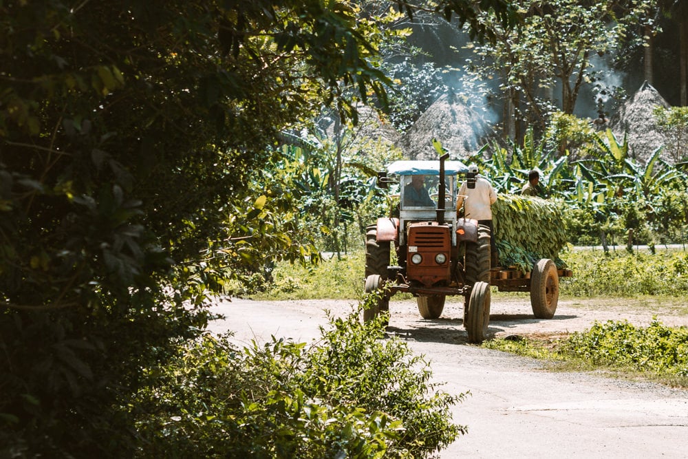
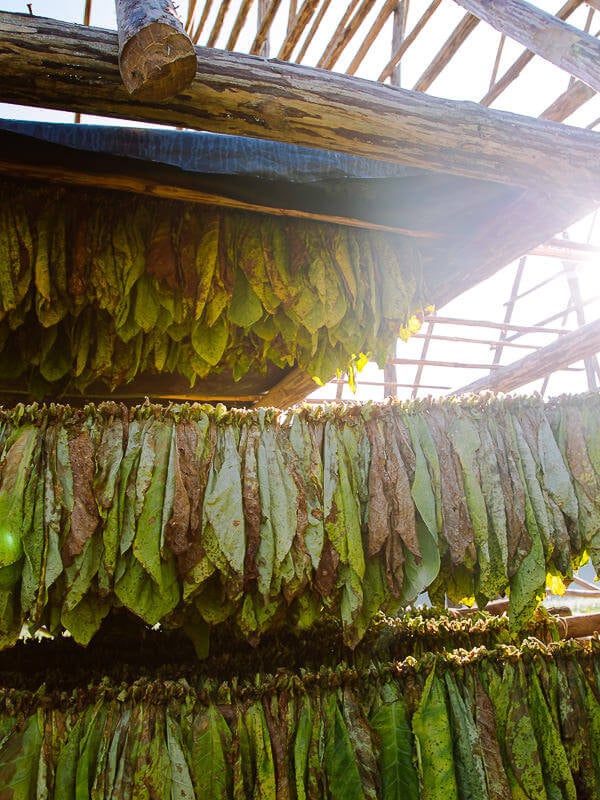
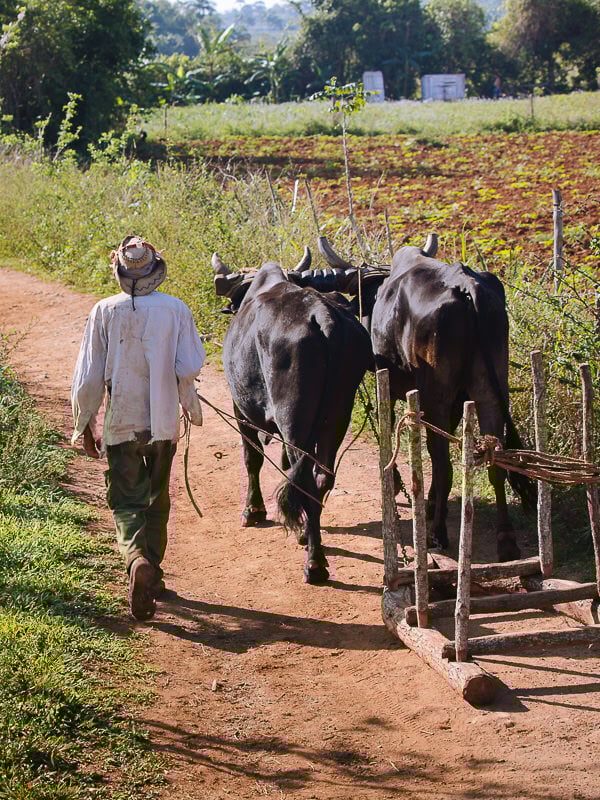
Farmers still work with oxen and home-made ploughs; tobacco leaves are dried in traditional wooden huts, and every sapling and seed is hand-planted.
The best way to enjoy the scenery and relaxed way of life is via the myriad of walking paths that criss-cross the region.
But there is little information and very few signs, so it’s easy to get lost. Some good tours are available with knowledgeable guides, but sometimes you just want to set off on your own.
Here’s our tailor-made map and instructions to help you enjoy the best Viñales Valley hike.
IN THIS GUIDE
Viñales Valley Hike Overview
SUMMARY
A half-day hike collecting the stunning mogote scenery of Viñales
DISTANCE
13 kilometres (8 miles) from Los Jasmines Hotel to Mogote Café
TIME
3 hours 30 minutes to 4 hours, 30 minutes
ELEVATION
100 metres descent and 30 metres ascent
BEST TIME
Jan-Feb
DIFFICULTY
Medium and may require wading across a shallow river
Idyllic Rural Escapism in VIñales
As usual, we found ourselves walking in the dark to start the hike. For a rural destination with minimal machinery, Viñales was surprisingly noisy.
Roosters – which every household appears to own – croaked the approaching dawn. Pigs oinked in muddy delight. The sighs of horses were audible over the chirping of cicadas.
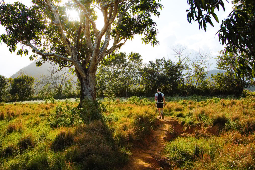
Just past the din of our farmyard friends, we arrived at Los Jazmines Hotel in time to watch sunrise light up the misty valley below. Clouds, not yet burnt off by the hot Cuban day, hovered below the top of Viñales most famous sights: its towering limestone mogotes.
A sea of green tobacco fields was cut by ribbons of rusty brown walking paths, which yesterday formed the route for our cycling in Viñales. Today, the spectacular scenery is the starting point for our hike.
A hike which took us down into the Vinales valley, past lush green tobacco fields and beautiful mogotes, before ending in the Valle de Palmarito.
We passed friendly farmers on homemade contraptions pulled along by oxen, cowboys on horseback who wouldn’t look out of place in an old western movie, and old characters sleeping under the shade of trees. It’s Cuba, uncomplicated.
Here’s how to do it.

Viñales Valley Hike Instructions
Most people who hike in Viñales hire a local guide, as the trail signage is insufficient for anyone trying to hike on their own.
As a result, we got lost several times. Like most things in Cuba, the trails operate a bit like a cartel; asking anyone for help was met with a firm: “obtener una guía!”
But we didn’t want to get a guide. And if you fancy the idea of conquering a beautiful Cuban walk at your own pace, here are our detailed instructions.
The total walk takes around 4 hours, and although it is not too challenging, there is a short, sharp descent and the possibility that you may need to take your socks and shoes off and wade through a shallow river.
The route can be tricky to find, so make sure you download our map at the bottom of this post and track yourself as you go.
Start / los Jazmines Hotel to el Cuajani Restaurant
The hike begins at the Sendero del Mirador al Valle sign 50 metres west of the Balcon de Valle restaurant, just east of Hotel Los Jazmines (1 on the map).
The first couple of hundred meters, as the trail drops down onto the valley floor, are the hardest and steepest on the walk. But there is nothing too difficult; it just requires some careful footwork.
At the bottom, the path reaches a field and splits.
Go left and follow the path through a tobacco field – you might even see some leaves hanging out to dry.
Head through some trees and then bear right on the path, keeping the large field on your left. Pass a shelter and just before a sign marked Mirador Casa Postal, turn right and follow the path around the mogote.
Pass another tobacco field and turn left just after the hut on the left-hand side of the path.
This path crosses a dry river bed before bending right and arriving at a T-junction.
Turn left at this T-junction and follow this path in a (fairly) straight line. As you get close to the road, bear right to meet it opposite the El Cuajani restaurant (2). Note: this is different from the El Cuajani marked on Google Maps.


El Cuajani Restaurant to Mural de la Prehistórica
Turn left onto the road where there are 2 choices: either turn right shortly after joining the road to head to the Mural de la Prehistorica (yellow line on map) or continue straight and take a longer route.
Taking the longer route, continue along the road and turn right at the ANAP Antonio Maceo sign (3) onto Calle Alfonso.
Stay on the grey-ish gravel track, keeping the mogote on your right and mangos on your left.
When you are almost halfway around the mogote, the main track heads away from it. Take the thick red-earth track on your right, staying closer to the mogote (4).
The path quickly passes a horse ranch and comes to Finca L’Armonia. Turn right and continue until you come to the Mogote Art Café – once here, turn right again.
The track now curls left and narrows. After a short time, there is a gate in the fence on your right. Walk through the gate to the Mural de la Prehistorica (5) in front of you.
There is a bar and toilets here.

Mural de la Prehistorica to River Crossing
Retrace your steps to Finca L’Armonia, then continue straight (instead of turning left as you came).
About 50m further, as a lake appears on your left, turn right to take the well-trodden red path (6), which had two black hoses running down it when we were there.
If you walk past the end of the lake to a white house with blue trim and a blue water tank, you have gone too far.
NOTE: If it’s time for a rest and something to replenish the energy levels, Café Mirador sits on top of the slight rise past the blue and white house. Wind your way up the track and take a break in front of some excellent views.
The well-trodden red path is the main route back to Viñales. The path cuts between two mogotes (the larger one on your right and a much smaller one on your left) before splitting.
Take the left fork, keeping the large mogote on your right.
Continue down this route until the path meets a river and becomes waterlogged (7). Sometimes someone here offers horseback rides across the water for a few US$ per person.
Other times, you’ll have to wade across yourself. The path is often muddy at the edge, but as you continue, it turns to gravel, making it easier to walk.
The river is usually shallow enough that you only need to take your socks and shoes off and roll your trousers above your knees. Bring a towel to help clean your feet at the end.


Back to VIñales
The path now slowly drifts away from the mogote on your right and splits again. You can actually go either way, but the shorter right-hand route (closer to the mogote) can be very muddy and wet.
So to keep your feet dry, turn left, then right and stay right until – facing the mogote – you come back to your original path, where you should turn left (8)
From here, the main path runs pretty straight (ignore the paths leaving at right angles) until it passes the end of the mogotes and begins to slowly bend right, completing a 90-degree turn.
Keep following the main path, ignoring a sign pointing left to Viñales (9). Just after passing Casa Fernando on your left, turn left, then immediately right to join another path (there should be a tree with a red dot in front of you as you join the new path).
This path passes the Cueva de la Vaca driveway and splits again. Take the left fork, which joins Calle Adela Azcuy Norte and leads you into town.
At the end of this Viñales Valley hike, we recommend you have a rest and grab lunch at Mogote Café. The food is good, and if you sit upstairs, you get a fine view over the fields you’ve just come from.
If you also need a coffee, the hotel on the main square does a surprisingly good cortadito and has access to the main square wi-fi.


Viñales Valley Hiking Map
Because there are no signs, it is important to have a map of the area. Our map shows you the complete route with numbers linked to the instructions to help you know where you are.
Click on the top right corner to open our map in your Google Maps app. Click the star next to the title to save it to your Google account.
Best Time to Hike in VIñales
The best months for our Viñales hike are the sunny yet slightly cooler months of January to April. It was still pretty hot when we did this hike (February), but not as scorching as it could have been.
With average high temperatures of about 26°C (79°F) in winter and 31°C (88°F) in summer, a hike like this is best avoided in the hottest months of the year.
Additionally, rain torments the island in May and sticks around until October.
Viñales Valley Hike Trail Conditions
The only difficult sections are the first 200m as the path drops down to the valley floor, and the wade across the river if no one is there to help.
The path is rusty red earth with very few rocks – great to walk on, but keep in mind it will be muddy after lots of rain and possibly a little bit slippery.
There are no signs for the path, so you will need these instructions and our map to help you along. Make sure you download the area to Google Maps.


How to Get to the VIñales Valley
Getting around Cuba is generally fairly easy with a good bus service and colectivos available to take you pretty much anywhere you want to go. Viñales Valley is no exception. Being only 180 km from Havana, transport is easy.
Bus – The Viazul bus runs twice a day and takes around 3 hours and 40 minutes. The price is 12 CUC per person. The Viazul buses are generally the most comfortable way to travel around Cuba; however, they can book out. Organise your tickets in advance to save the stress.
Colectivo – Your casa particular can also organise a private taxi or colectivo, both of which take around 2 hours. A private taxi should be around 80 CUC per vehicle; the colectivo around 15-25 CUC per person.
Refreshment Options on This VIñales Valley Hike
In Cuba, getting food outside a state-run restaurant can be difficult. Purchasing food to take with you for a snack on the hike will be nigh on impossible. Your casa particular host may supply you with some rations; however, there are enough options on the hike to sustain you.
The Mirador Los Jazmines Hotel, where this Viñales Valley hike starts, has a bar which serves pretty good coffee at 7:00 if you ask nicely. (They actually open at 8:00).
The Balcon del Valle restaurant is near the hotel, and you can get a hearty breakfast of toasted sandwiches starting from 8:00.
Café Mirador is just a 5-minute detour after leaving Mural de la Prehistorica, where you can get a refreshing drink in a stunning location.
Back in Viñales, we recommend lunch at Mogote Café. It’s standard Cuban fare, but it’s close to the end of the trail, the staff are friendly, it’s well priced, and you have a nice view from their upstairs terrace.


Tips for Hiking in the VIñales Valley, Cuba
This is a delightful walk through local farming country, with few tourists around except for a couple on guided tours. With our map, we’d hope you find it relatively straightforward to complete, here are some additional tips to keep in mind.
Timing
1 / We recommend leaving early when the light for photos is at its best, the view from Los Jazmines Hotel at its most magnificent and the temperatures at their coolest. Grab a taxi or walk up the road to the hotel, arriving as close to sunrise as you can manage.
2 / Allow a good 4 hours for the hike from Los Jazmines into Viñales, including time to stop for a few photos and a couple of minutes to wait for your horse to take you across the swampy section.
3 / Before you start the hike, download Google Maps for the Viñales Valley to your offline maps. Also, save our map by clicking on the star.
4 / The only difficult walking section is the first 200m as the path drops down to the valley floor – it’s a little steep, so some careful footwork is required.
5 / Around 2/3 of the way around, you will face a shallow river. If you are lucky, you can hitch a ride with Oswaldo or a member of his family on the back of a horse. If not, you’ll have to wade across. It is usually quite shallow but also quite muddy at the edges.
6 / The path could be slippery and muddy after rain, so keep an eye on conditions.
What to Take
7 / Doing this walk in trainers would be no problem; however, you might want something more waterproof if there has been a lot of rain. Bring something to dry your feet after wading across the river.
8 / Don’t forget your camera, as the scenery is stunning the whole way around.
9 / The walking is straight forward, although the heat can be draining, so make sure you take plenty of water and wear sunscreen and a hat.
Getting Help
10 / If you get lost, try asking one of the guides or café owners in the area. While some locals wouldn’t give us instructions, we found a guide who was happy to help.
11 / The local farmers are very friendly on the way around this hike. However, they may want to divert you to their tobacco factory or other local attraction. Make sure you don’t confuse this for instructions you might have been trying to get for the hike.
12 / If you need to (or want to) break the walk, a bus runs (about every 90 minutes) from the Mural de la Prehistorica back into town. Otherwise, taxis can regularly be found ploughing the main road.


Where Next?
Cuba is a unique place. Years of Soviet-funded political ideology created a strong- if slightly confusing – sense of national identity. Soviet, American, Spanish, Caribbean and African influences fuse together to create a fascinating place to visit. Here is some more of our reading about this fascinating place.
Our complete guide to Trinidad
Viñales Valley – cycle routes through Cuban tobacco farms
How to visit Cuba’s Ciénaga de Zapata National Park
Explore the best scenery in Cuba on this Viñales Valley hike
Impressions of Havana – a story from the streets

reader-supported
When you buy through links on our site, we may earn a small affiliate commission at no extra cost to you.
Thanks for your support // Paul & Mark
Great post. Very easy to follow guide and the pictures look fantastic. I’ve never been to that area of the world but it’s something I’ve been thinking about a bit more recently.
Thanks, Stuart. It’s a very interesting place. It can be a little challenging to travel around sometimes, but the scenery is fantastic.
What an interesting experience! I’m a little surprised you went without a guide and when I think of tobacco fields, I guess I think of them being heavily guarded, so I find it odd that it was so safe for you to just go as you please. #FarawayFiles
Yes, it definitely felt very safe. I guess because it takes quite a bit of work and a lot of expertise to turn raw tobacco plants into cigars that it’s not a target for theft. The raw material is also not that expensive because it’s not illegal. But, Viñales is a great place to take yourself on a hike.
Thanks – so interesting to read about this side of Cuba. I normally hear about Havana and the beaches, lovely pics too
#farawayfiles
Thanks a lot. There’s a lot of beautiful scenery in Cuba, Viñales is just the beginning. Stay tuned for lots more articles about non-Havana locations!
Live the detail of your post. It’s easy to follow and beautifully illustrated.
As always your photos are stunning! Interesting that you mention the farmers had little to no machinery to help with their operations. Is machinery even an option for them? It seems like this isn’t something they do by choice? I’ve always read that Cuba and its people are without most of the modern technology the rest of the world takes for granted, and I would assume this also applies to its farmers? Fascinating post and as always I love following along on your fabulous journeys. Where to next? #farawayfiles
No, it’s not something they do by choice. It’s part poverty and part government restrictions on inported goods. When the Soviet Union collapsed and Cuba lost its funding, they had little choice but to rely on traditional farming methods, which still continues today. Thanks for your nice comments Hilary, we’ve just come back from Morocco so stay tuned for that.
This brings back fond memories of my visit to Vinales. As much as I love getting back to nature hiking is sadly not for me due to stupid health conditions, but I still highly enjoyed seeing what I did of the area. I’d have adored to experience what you did though, what a beautiful day you must have had! (and I bet you slept well that night lol)
Thanks, Keri. It was a great experience, I was a bit surprised we eventually found our way back too Viñales, but it was well worth it.
Love this guys – it’s a great guide to encourage more people to go it alone, without a guide! Will look at flights to Cuba now…
Thanks Luke! I hope we can encourage more people to go without a guide because it’s not that easy in Cuba – there’s always plenty of people offering to take you somewhere! But, getting off the tourist trail in Viñales was one of the highlights of our trip. You guys should head out there, you’ll love it!
Your photos are stunning as always. Definitely saving this for later, I would love to hike here and I hadn’t heard of it before reading your article. The sunrise views look *incredible*! #farawayfiles
Really useful tips. It looks incredible. And good to have all this practical advice. I’d hate to accidentally end up in a tobacco factory!
Yo, just used your instructions as of 8th of November. Everything went well 10/10. Any problems I had were easily fixed by remembering that overview map you had. The checked points were very useful for staying on track, good job
Thanks for letting us know, always great to hear. So glad our instructions made sense to someone else! Enjoy Cuba.
Hey Paul
Splendid article
I’ll head to Viñales in few days and will definitely do that hike
Surprisingly I can’t save your moi as it looks that Google Maps « engine » stop working
Any chance to use that map differently?
Thanks again!
Mona
Hi Mona, thanks for getting in touch glad you found it useful. You may have trouble saving the map if you are in Cuba as some google services are banned. If you are clicking on the star to save the map (or loading it into google maps on your phone by clicking on the box on the right-hand side) and it’s not working you may need to use a VPN to save the map. Hope this helps and have a great time in Viñales. Paul.
Hey Mark and Paul!
We’ve just got back from Cuba and we wanted to thank you for your amazing guide! There’s no chance we could have got to those places on our own.
The journey turned out to be a bit adventurous on the “dirty part” of the track. For some reason, we believed it would be 20-30 m long but it turned out to be muuuuch longer ? As you said, it can be crossed only if someone ferries you, but when we were hiking, there was no Oswaldo there. We were lucky to meet some local guys on oxen carts who hitched us absolutely for free, but it was just a fortunate coincidence. Anyway, the views were worth all the struggles, and the adventures are a great thing to remember))
Hi guys – Thanks for letting us know you had this great experience. It’s such a wonderful part of Cuba. Sorry to hear Oswaldo wasn’t there, but I’m glad someone else was on hand to help you out!
Mate you’re a legend for posting this. My wife and I followed these instructions (Using screenshots from your web page) and were able to complete this hike without too much difficulty. It was about 17km according to our calculations but that included walking from the centre of town to Los Jasmines to start.
Only really three alterations that I would make to the instructions
(1) Start/Los Jazmines Hotel to El Cuajani restaurant – There was no sign at the bottom of the hill, just a fork. Unfortunately a helpful local pointed us right instead of left so we got briefly lost. Traced back and went left.
(2) Mural de la prehistoric to river crossing – Couldn’t find the ‘ENTRE MOGOTE’ sign but I noted on the map the ‘Finca L’Armonia’ which we used as the landmark.
(3) Oswaldo still not there. Unfortunately the river was quite high when we visited. Ended up taking our shoes off and just walking across. Never got above knee height. Once you get to the actual stream proper the ground is gravel and quite solid underfoot, it’s just the edges that are muddy and require a bit of thought.
Overall we had a great hike and wanted to thank you for the instructions.
Cheers!
Hi Rowan,
Thanks a lot for your generous and helpful comment. I am glad you had a great day out. I have updated the post with the information you have left us – so hopefully the next hiker can find their way even more easily. Hope you had a great time in Cuba. Thanks again, Mark
Hi, we have just finished your hike. It was perfecto :). The river was completely dry so no problem with that. I would just want to add that we went to the Baloney of Vinales cafe/restaurant just next the Los Jazmines Hotel for the view. We prefer to support the local community.
Hi Lauren, Glad you had a great walk and thanks for the tip. Hope you had a great trip to Cuba. Enjoy your travels. Mark.
I did this hike today, and it is truly amazing! Thank you for very precise and easy-to-follow instructions.
A few notes: It’s probably been a while since you were here in Valle de Viñales and since then the sign at the beginning of the tour is partly gone, and only the first word remain. As your instructions for this part of the hike are so detailed, I was quite sure, what to do though.
Also at the end of the first downhill track, the path to the left has now been “closed” by barbed wire. It is quite easy to crawl under, but it made me stop and wonder for a moment derfor I went on.
The last thing is the path from the Mural. I got there from the “short” route, but I could not find the trail further on, so ended up going back and do the long route. I wouldn’t have missed it though!
Thanks again for a great hike! I will definitely check out this blog next time I am travelling.
Hi Lauren,
Thanks so much for your nice comments and the additional info. We’ll update the post.
Paul.