Dyrhólaey Peninsula, on the tip of Iceland’s southern coast, is blessed with great scenery, puffin spotting, and views of Reynisfjara Black Sand Beach. Here’s our complete guide to this unique coastal destination.
By: Mark Barnes | Last Updated:
Lying at the southern tip of Iceland, where the land of fire and ice extends into the Atlantic Ocean, the Dyrhólaey peninsula is a small volcanic promontory that was once a separate island off the mainland coast.
From the summit, wonderful views stretch across the Reynisfjara Black Sand Beach to needle-thin stacks, natural arches and distant islands as puffins dive towards the sea and return with a beak-full of fish.
In just a few short miles, the Dyrhólaey peninsula contains many of Iceland’s must-visit destinations, and best of all, each site is completely free.
Here’s our complete guide to Dyrhólaey Peninsula & Reynisfjara Black Sand Beach, including how to get there, what to see, and where to stay nearby.

Where Is Dyrhólaey Peninsula & Reynisfjara Beach?
The Dyrhólaey peninsula is a rocky promontory that juts out into the Atlantic Ocean in south-central Iceland. Rising to a height of 120 metres, it’s the southernmost tip of the country.
The nearest town is Vík, which is only 2 miles (3 kilometres) to the east. However, the road from Vik to Dyrhólaey completes a large 12-mile loop and takes 20 minutes.
Reynisfjara Beach is a black sand beach wedged between the cliffs of the Dyrhólaey peninsula and Vík.
Dyrhólaey Peninsula & Reynisfjara Beach Map
The below map has the 3 main places to visit at Dyrhólaey. The Upper area (Háey) in marked in red, Dyrhólaey Lower (Lágey) is marked in purple, and Reynisfjara beach is marked in brown.
Click on the top right corner to open our map in your Google Maps app. Click the star next to the title to save it to your Google account.
How to Get There?
By Car
Dyrhólaey is a 2-hour 30-minute drive from Reykjavík or 20 minutes from Vík.
The Dyrhólaey Peninsula is split into two sections, each with its own parking lot. Access to Reynisfjara Beach is at a separate location, 20 minutes away.
Upper Section
The upper (western) section is called Háey, and it’s here you’ll find Endless Beach, Dyrhólaey Lighthouse and Dyrhólaey Arch (red on the map below).
Lower Section
The lower (eastern) section is called Lágey, which has the best puffin spotting opportunities and views over Reynisfjara Beach (purple on the map).
Driving Conditions
To explore both, which we highly recommend, you can either drive between the two parking lots (a 5-minute drive) or walk along the clifftops (a 25-minute walk each way).
The road between the two car parks can be a bit rough, but it is usually passable in either a 2wd or 4wd vehicle. Be aware that during nesting season, the upper car park can sometimes be closed.
All the car parks are free of charge.
Reynisfjara Beach
It is not possible to access Reynisfjara Beach from the Dyrhólaey Peninsula. Instead, you need to drive for 20 minutes (14 miles) to the Reynisfjara Beach parking lot, marked as brown on the map.


By Tour
Tours run from Reykjavík and take all day (approximately 10 hours), making regular stops along the way.
1 – Waterfalls & Reynisfjara // This south coast tour runs from Reykjavík with excellent views of the Eyjafjallajökull glacier on the way. It visits the waterfalls of Seljalandsfoss and Skógafoss, before stopping at Reynisfjara beach to see the basalt columns.
2 – Eastern Viewpoints // This south coast tour also departs from Reykjavík and follows a roughly similar itinerary to the one above. However, a stop is added at the eastern end of the Dyrhólaey Peninsula, where you get great views of Reynisfjara beach from above and good puffin spotting opportunities (April to August).

What to Do at Dyrhólaey
1. Endless Beach Viewpoint
At the western end of the Dyrhólaey Peninsula, Endless Beach Viewpoint has sweeping views from the 120-metre-high cliffs.
Also known as Dyrhólaey Beach, a wide black beach extends down the coast with a green moss-covered lava field marching towards the sea.
The view from the headland is remarkable and unique. The vast swathe of black sand, accentuated by the white strip of crashing surf, forms a natural leading line towards the giant Mýrdalsjökull Glacier in the background.
On a clear day, which we didn’t have, you might even see Vestmannaeyjabaer Island in the distance.
How to see the Puffins – If you’re visiting between May and August, keep an eye out for puffins nesting in the cliffs. Dyrhólaey is one of the most accessible places in Iceland to spot them up close.

2. Dyrhólaey Lighthouse
Perched on the western end of the promontory, Dyrhólaey Lighthouse, built in 1927, is a square, concrete tower standing 13 metres tall.
You can get to the lighthouse via a short, windy path from the upper car park. Along the way, you’ll get sweeping views of the Dyrhólaey Arch, where waves crash through a massive rock bridge, and the Reynisdrangar Needles, a cluster of basalt sea stacks jutting out of the ocean.
The cliffs here are also a hotspot for birdwatching, especially during puffin season (May to August).
We had a great time photographing them as they huddled among the rocks in between fishing trips, which you can see in our images below.

3. Dyrhólaey Arch Viewpoint
Dyrhólaey which means “the hill island with the door hole,” is named after a natural arch underneath a small section of the peninsula jutting out to sea. The arch is wide enough that small boats can pass under it.
The closest and best angle to photograph the arch is from Dyrhólaey Arch Viewpoint, around 100 metres past the lighthouse. From here, you’ll get a clear side-on view of the arch with the ocean beyond. It’s especially photogenic here in low-angle morning or evening light.
While this is the most direct view, the Reynisfjara Black Sand Beach Viewpoint, a little further along, has a more elevated, sweeping perspective.
From there, you can frame the arch against the black coastline, crashing waves, and — on a clear day — the distant peaks of Eyjafjallajökull and Mýrdalsjökull glaciers.

4. Reynisfjara Black Sand Beach Viewpoint
At the eastern end of the Dyrhólaey Peninsula near the Lágey car park, there are wonderful views over Reynisfjara, the Black Sand beach.
National Geographic ranked this stretch of sand as one of the best beaches in the world. The contrast between the inky shoreline and the foaming Atlantic waves is nothing short of surreal.
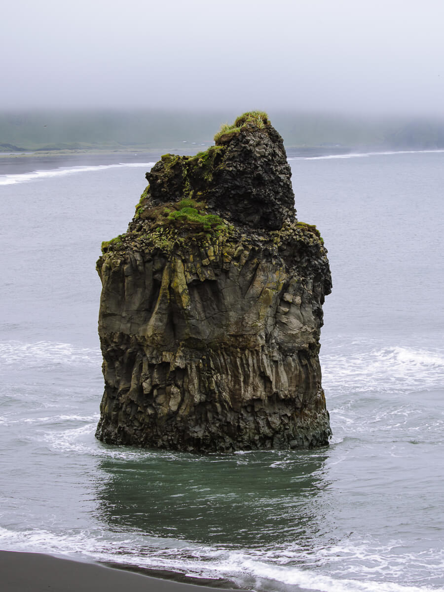
Just in front of Reynisfjara, another smaller black sand beach called Kirkjufjara has one of Dyrhólaey’s most photographed landmarks – Arnardrangur, or “Eagle Rock.”
This striking sea stack once served as a nesting site for eagles, and today it stands proudly at the tide line, constantly battered by waves.
How to get there? – The easiest access to the viewpoint is from the lower road parking area.
Safety – Kirkjufjara Beach is exceptionally dangerous due to the sneaker wave and the high risk of rockfall, so you are strongly advised not to go down there.


5. Puffin Spotting at Dyrhólaey
Right next to the Reynisfjara Black Sand Beach viewpoint, the clifftops on the Dyrhólaey peninsula are covered in a sloping tuft of grass which provides the perfect set-up to capture puffin shots.
If you are visiting during puffin season, this is the best place on the entire peninsula to photograph them. Puffin seasons run from April to August. However, the highest activity is from mid-May to July.
You may have to hang around, and it’s helpful to have a telephoto lens, but even in wet and windy conditions, your chances of capturing them are good.
Dyrhólaey Closures – To protect the puffins, Dyrhólaey is not open to the public between 7pm and 9am. It may also be closed completely for several days around the first week of May, over the peak breeding season.
Respect the Puffins – Please stay on marked paths and stay quiet around the puffins. Never try to touch or feed them and make sure you don’t accidentally block access to their burrows. Using drones near the nesting cliffs is generally prohibited, as it can severely stress the birds


6. Reynisfjara Black Sand Beach
Even though Reynisfjara Black Sand Beach is just below the eastern end of Dyrhólaey Peninsula, it is not possible to walk straight onto the beach.
Instead, you need to loop around via a 20-minute drive to reach the dedicated parking area near the village of Vík.
Black sand beaches appear when lava from a large volcanic eruption flows into the sea and cools quickly. Reynisfjara was formed from one of Katla Volcano’s major eruptions.
The natural spectacle of Reynisfjara has been immortalised on several popular Hollywood works including Game of Thrones, Noah, The Force Awakens, Rogue One, Star Trek Into Darkness and The Secret Life of Walter Mitty.
Safety Note – Although it looks appealing, Reynisfjara beach is extremely dangerous. Sneaker Waves can suddenly reach much further up the beach, dragging people out to sea. Be extremely careful if you decide to go down to the beach. Never turn your back on the ocean here, and stay well clear of the water’s edge — even on seemingly calm days.

7. Gardar Basalt Columns
The Gardar Basalt Columns are at the eastern end of Reynisfjara Beach, right next to the parking lot. These tightly packed columns are so carefully arranged that it’s difficult to imagine they were formed by nature.
Basalt columns form when basalt lava from a volcanic eruption cools very quickly, causing the rock to crack into long, geometric columns.
This process is called columnar jointing. The columns are usually hexagonal, and over time, they can form vertical cliffs or terraced steps. Iceland’s cold temperatures and volcanic activity create the perfect environment for these columns.
The Gardar Basalt Columns at Reynisfjara are among the finest in Iceland. While the largest collection can be found at Stuðlagil Canyon — which we highly recommend visiting if you have the chance — the Gardar Columns are right on the beach, making them more accessible than Stuðlagil, which requires a hike to reach.


Where to Stay?
There are a host of great places to stay in Iceland near Dyrhólaey. One of the best places to base yourself is Vik. Here are some suggestions.
- The Garage – Just 10 miles from Seljalandsfoss, The Garage is a cool Icelandic stay with fully equipped kitchens, private bathrooms, laundry facilities and scenic terraces.
- Hotel Vík Í Mýrdal – A clean comfortable hotel with friendly service and an on-site restaurant and bar. The rooms are spacious and well-appointed. Breakfast is simple but does the job.
- Hotel Katla by Keahotels – Located just outside Vík, Hotel Katla is a modern hotel with clean, comfortable rooms and friendly Icelandic service. The buffet breakfast is substantial.

Important Information for Visiting the Area
Dyrhólaey Peninsula
01. During puffin nesting season, the upper parking lot (Háey) is sometimes closed.
02. Visitor hours are restricted during puffin season (around April to August) and Dyrhólaey will be closed from 7 pm.
03. Allow at least 2 hours to explore the Dyrhólaey Peninsula. There are lots of great viewpoints, and you’ll probably want to spend some time capturing the perfect puffin shot.
04. Parking is free, and there is no charge to enter the site.
05. There are toilets in the lower parking lot (Lágey), which cost 200 ISK ($1.50) and can be paid by card.
06. There is no food or drink at either the upper or lower parking lots.
07. It can be cold, wet and windy at Dyrhólaey, even in Summer, so bring a hat, gloves and a raincoat.
08. The paths to the viewpoints are in good condition but rocky in some sections.
09. You can get up close to the puffins, but a telephoto lens is recommended.
Reynisfjara Beach
10. Allow about 1 hour to walk along the beach and see the basalt columns.
11. Be very careful of the freak waves at Reynisfjara called ‘sneaker waves’, which have been known to drag people into the sea.
12. Visiting and parking is free, and there are toilets in the parking lot.
13. Black Beach Restaurant, next to the parking lot at Reynisfjara, serves food from 11am to 8pm.

What Else to Do in the Area?
Some of our top places to visit in Iceland are not far from Dyrhólaey. A few of the highlights are –
Katla Ice Cave – Take a super jeep tour down a rural road, hike across the Kötlujökull Glacier with provided crampons, and explore the blue and black ice cave.
Skógafoss and Seljalandsfoss – Two of the best waterfalls in Iceland are only about 30 minutes’ drive away.
Abandoned DC Plane Wreck – An Instagram favourite. A 1973 plane wreck sits ruined on the black beach at Sólheimsandur. The parking lot is 15 minutes from Dyrhólaey, from where it is a 45-minute walk (each way) across the black sands to the plane. We haven’t done this because it seemed like too much time and effort to get to when there are so many great sights in Iceland.
Maelifell – If you have a 4×4 and fancy a bit of adventure, head to Maelifell. This green cone-shaped volcano rising out of a plain of black sand and rock is one of the iconic sights of Iceland. Find all the information you need on our Maelifell guide.

More Iceland Ring Road Guides
- Check out our 10-day Iceland Ring Road itinerary.
- Make sure you don’t miss our favourite places to visit in Iceland.
- Looking for accommodation on the Ring Road? Here’s where to stay in Iceland.
- Don’t miss a thermal soak with our guide to the best hot springs in Iceland.
- Just off the Ring Road is Iceland’s newest volcano – Fagradalsfjall.
- The best way to spend a day seeing Iceland’s iconic Golden Circle.
- Tips for getting good pictures of the puffins at Dyrhólaey Peninsula.
- When driving the Ring Road, don’t miss Vestrahorn – Bat Mountain.
- How to spend a few days exploring Myvatn.
- A complete list of our favourite waterfalls in Iceland.

reader-supported
When you buy through links on our site, we may earn a small affiliate commission at no extra cost to you.
Thanks for your support // Paul & Mark
Excellent detailed information, thank-you. We will be staying in Vik next year so I have been researching.
This is by far the most detailed information I have come across for this area.
I really appreciate the map and the downloadable KML file which I will use offline on my tablet. I will also bring my 600mm f4 as you suggest and I did when taking photos of puffins in our Newfoundland, Canada.
Thanks again, and cheers from Canada
Hi David – Thanks a lot for your kind words, means a lot. Have a great time in Iceland!
Paul.