El Torreón is the highest peak in Sierra de Grazalema. After a satisfying hike to its summit, views on a clear day can extend as far as Africa. Here’s what you need to know.
By: Paul Healy | Last Updated:
Sierra de Grazalema, in the centre of Andalucía, is a hidden gem for hikers. In early spring, while many of Europe’s hiking areas are covered in snow, Sierra de Grazalema can be bathing in glorious sunshine and colourful flowers.
It’s the perfect time to explore its dramatic canyons, lush green vistas, and craggy mountains,
Rising above everything else in the park is the triumphant peak of El Torreón. The 360-degree views from the 1654m summit collect the mountains, valleys and white villages of Andalucía, down to the rock of Gibraltar and the oceans that surround it.
If you are lucky you may also see Africa, shimmering on the horizon.
Conquering the highest peak in a region is always a rewarding challenge. Fortunately, the path to the top begins high up on the mountain road, so it’s less than 800m of ascent to reach the summit. The result is excellent views without excessive effort to get them.
Here are all the details including how to get the permit required to hike el Torreón.
IN THIS GUIDE
Hiking el Torreón
SUMMARY
A half-day hike steeply ascending the highest peak in the park
DISTANCE
3.2 km each way – 6.4 km in total
TIME
3 hours 10 minutes for the complete round trip
ELEVATION
780 metres (+/-)
BEST TIME
April – May
DIFFICULTY
Medium
PERMITS | WHEN | TRAIL CONDITIONS | MAP | WHAT TO TAKE? | GETTING THERE | WHERE TO STAY? | MORE GUIDES
Hiking el Torreón
After starting a road trip from Granada, the mighty buttresses of El Torreón rose above us.
It was the first of April and a truly glorious day, but it’s not a walk to dawdle on. The path rises from the car park at 865m to the 1654m summit and it is pretty unyielding.
We began contouring around the shoulder. Mostly in the shade of the trees, we occasionally popped out into the sunshine for glistening views to the west.
The start of the el Torreón hike is about putting some height behind you.
For an hour we puffed and panted our way up the relentlessly rising path. After some steep zigzags, the trail flattened for a while, giving us a chance to catch our breath and realise how beautiful this part of Spain actually is.
We followed the green and white markers up the final assault on the peak.
El Torreón Summit
The last 100m of ascent is a fun scramble up the rock face.
Tired legs were pleased to work with the assistance of hands as we pulled ourselves up the craggy face. It’s a bit steep but there was nothing too challenging and the reward was magnificent.
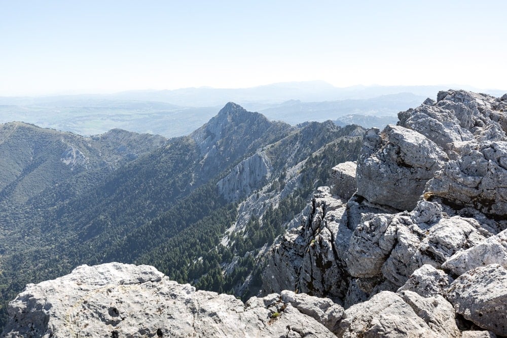
All alone, we sat and surveyed the 360-degree views across dark forests, craggy mountains and white villages glistening in the sun.
Gibraltar rose out of the ocean to the south as the plains of Andalucía stretched to the west. We basked in the sun, got our breath back and took a well-earned rest.
There’s something exceptionally rewarding about conquering a mountain, no matter how small that mountain is. El Torreón is not exactly Everest, but the feeling of satisfaction at getting to the top is still worth celebrating.
Unfortunately, we only had a couple of chocolate biscuits left, but a celebration it was.


How to Get a Permit for Hiking el Torreón?
Permits must be booked in advance to hike el Torreón.
You can book up to 2 months in advance and it’s a good idea to book as early as possible.
Booking link – juntadeandalucia.es
You need an email address, phone number and passport number to apply for tickets.
The booking form is only available in Spanish, so here are the steps you need to follow:
- Step 1 – Click on particulares (or individuals if you have automatic translation on).
- Step 2 – Click on Accesso sin certificado digital.
- Step 3 – Add your passport number by selecting “otros” from the drop-down menu.
- Step 4 – Select Sierra de Grazalama Natural Park
- Step 5 – Select Sendero El Torreón (or The Tower Trail) from the Actividad menu
- Step 6 – Select your dates and add your personal information.
Once you fill out the form, you will get a confirmation email. You must click on the confirmation link (CONFIRMACIÓN DE LA RESERVA) within 25 minutes to validate your tickets.
After you click the confirmation link you will get another email with your tickets which you can show to the forest guard on your mobile.
The permits are free.
When Can You Hike el Torreón
Sierra de Grazalema is one of the last places where the Spanish Fir (or Pinsapo) grows. The park looks after the few that remain with a lot of care.
Therefore, during the summer season (1 Jun to 15 Oct) when forest fires are a risk, hiking is not allowed El Torreón at all.
In our opinion, the best time of year to hike El Torreón is throughout April and May. At this time, the glorious wildflowers of the region are in full bloom, any snow should have cleared, the temperature should not be too hot and tourist numbers will be slightly lower.
The hike can be done any time of day, but the visibility is usually crisper and clearer in the morning before the clouds and haze builds.

Trail Conditions for Hiking el Torreón
El Torreón trail is very clear and easy to follow (unless there is snow on the ground).
As it rises above the zig-zags and flattens it’s a little less clear but green and white ringed wooden posts mark the trail and allay any fears you are going wrong.
There is 780m of ascent and descent so the hike requires some considerable effort, but at no point is the path particularly steep or challenging. It’s just a matter of putting one foot in front of the other and taking some breaks when legs are starting to feel the strain. The last 100m is a fun scramble up a rocky summit, where you may need to use your hands.
It takes about 1 hour 45 minutes to reach the summit and another 1 hour and 25 minutes to descend the same way. Allow 3 hours and 10 minutes for the round trip and another half hour to take in the views.
From the summit it is possible to head westwards over a series of summits to el Llano del Campo which would take about 6 hours.
Another much more technical trek, heads eastwards over the summit of Pico San Cristobal to the El Pinsapar trailhead, which also takes about 6 hours.
El Pinsapar Trail Map
Although the path is relatively clear, whenever you head up to a peak where weather conditions can change quickly, you should take a compass and a map. We recommend this one.
Click on the top right corner to open our map in your Google Maps app. Click the star next to the title to save it to your Google account.
What to Take with You
01 – The El Torreón trail is not long or difficult but good solid walking shoes are always a good idea.
02 – Take a map and a compass in case the cloud comes over suddenly. You don’t want to go wrong on these steep slopes.
03 – Half the walk is spent in the sun and the other half in the shade of the trees. Wear sun block and a hat to help protect from that sizzling Spanish heat. However, in the shade and on the summit it can get quite cold, especially if the wind is blowing, so bring some layers to rug up a little.
04 – There are no refreshments on the route so make sure you have some water and some snacks to give you an energy boost for the relentless tiring climb.
05 – Take a camera and, if you are a bird-watcher, a pair of binoculars.
06 – Don’t forget your permit!

How to Get to el Torreón Trailhead
The El Torreón trail is in Sierra de Grazalema, a natural park which is a 1-hour 30-minute drive from either Seville or from the beaches of Marbella, or around 2 hours from Granada.
The trailhead begins at a car park located just past the 44km marker on the A-372, which runs from Grazalema to El Bosque.
A bus runs along this road but only twice a day, once early in the morning and another late in the evening. So you will either need to have your own car or take a taxi (+34 666 842 973) to the trailhead.
Car Rental // For a hire car while visiting the villages, we recommend rentalcars.com. They provide a cost comparison across all the major can rental companies making it easy to see the best rates.
Where to Stay for Hiking el Torreón
The closest places to the el Torreón trailhead are the white villages of el Bosque or Grazalema.
El Bosque has the benefit of the visitor’s centre which is good if you have questions, but it does not have a dramatic location.
Grazalema sits in picture-perfection at the base of some beautiful craggy mountains but dies in the evening.
So we suggest you head a little further away to Zahara.
Sitting on a hill just under a Moorish castle, Zahara has magnificent views and great walks. But best of all it has a couple of decent restaurants in a cute square.
We suggest you stay at Alojamiento Rural el Pinsapo and head to Cerveceria el Gallo for its tapas.
More Helpful Andalucía Guides
- Read about our favourite places to visit in Andalucía.
- Relax on the Costa del Sol with our guide to the best beach bars near Marbella.
- Our guide to the best things to do in Granada has the top attractions plus the best tapas.
- The Caminito del Rey hike is one of the most stunning in Spain.
- Discover the best places to visit on the Costa del Sol.
- Get off-the-beaten track on the El Pinsapar Trail in Sierra de Grazalema.
- Soak up the sun at these beautiful beaches near Tarifa.
- Visit el Torreón, the highest peak in Sierra de Grazalema.
- Fancy a strenuous walk? Try the La Concha hike.
- Discover all the best things to do in Seville.
- What to do in Mijas on a day trip.

reader-supported
When you buy through links on our site, we may earn a small affiliate commission at no extra cost to you.
Thanks for your support // Paul & Mark