The only way to get to Lago di Sorapis is to hike. But what a hike it is. The turquoise lake nestled under imposing mountains is accessible by narrow ledges on stunning paths. Here’s what you need to know.
By: Mark Barnes | Last Updated:
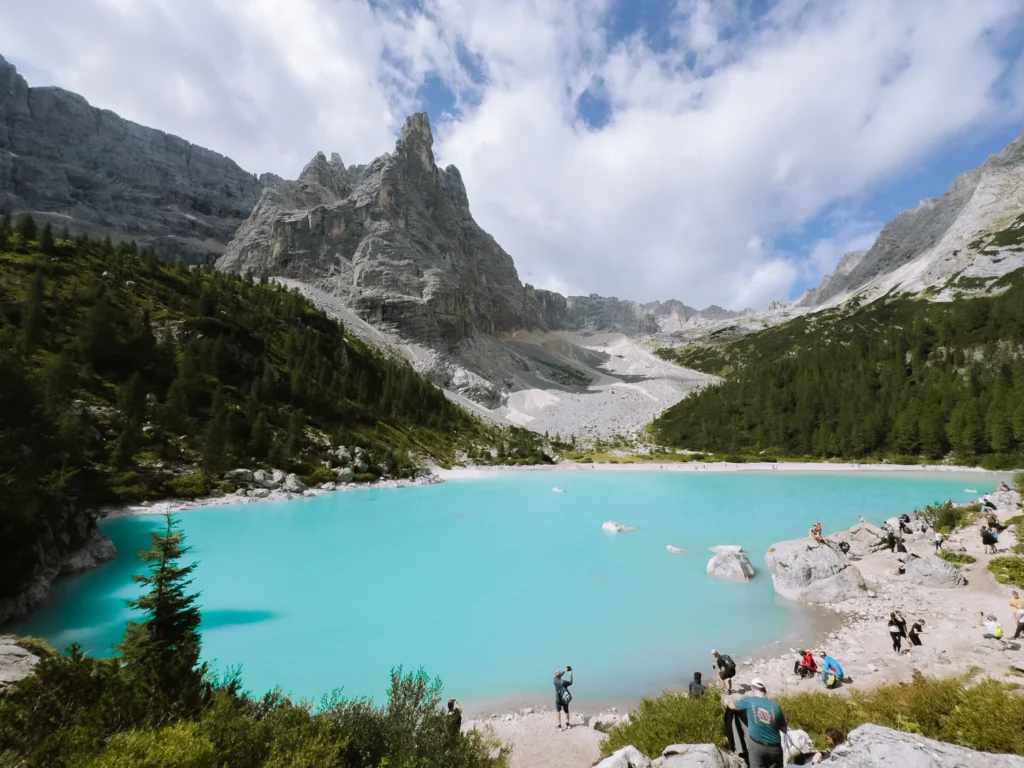
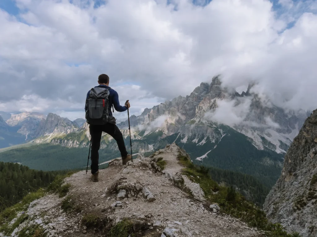
Set on a remote ledge, backed by the towering 3,200-metre Mount Sorapis, the turquoise lake of Lago di Sorapis is a stunning destination in the Dolomites.
The easiest way to get to the lake is a there-and-back hike from Passo Tre Croci. The hike takes about two hours each way and requires some legwork, but the rewards are well worth it.
The views on the hike are stunning, and the lake itself, under the huge rocky façade of the mighty Mount Sorapis, is breathtaking.
However, this there-and-back route to Lago di Sorapis has become extremely busy over the summer months.
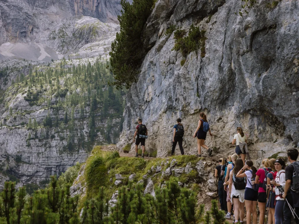
There are a few cable-assisted sections over narrow ledges and metal staircases, which had lengthy queues on our last visit. This makes the route a bit longer than it otherwise would be, and with lots of people, some sections require more care.
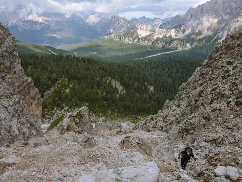
Paul and I took an alternate route over Forcella Marcoira. This trail is much more challenging, with a tricky scree section and steep descent. But if you are an experienced hiker, this route has far fewer people on it.
In this post, we provide instructions for both routes, along with all the necessary information for a safe hike to Lago di Sorapis.

How to Get to the Lake Sorapis Hike?
Both hikes begin from the car park at Passo Tre Croci, which is 10 kilometres from Cortina d’Ampezzo.
By Car
It’s a short drive (20 minutes) from Cortina to Passo Tre Croci. There is free parking available along the side of the SR48 road between the Rifugio Baita Son Zuogo and the Lago di Sorapis trailhead; we have marked the locations on the map below.
In peak season, the parking spaces can fill up very fast. We arrived at 7:00 AM and took one of the last available places.
If there are no spots on the side of the road, there is a nearby free car park marked as Parcheggio pubblico gratuito Rio Gere on Google Maps. This adds about 20 minutes each way to the walk.
By Bus
An hourly bus runs from Cortina to the Lago di Sorapis hike start point every hour from 6 AM to 11 AM. There are return journeys in the afternoon up until around 5:45 PM. Check the latest schedules at the DolomitiBus Website.


Lago di Sorapis Map
The paths on the there-and-back hike (marked red on the map below) are clear and very easy to follow. The fact that it is often so busy makes it virtually impossible to get lost.
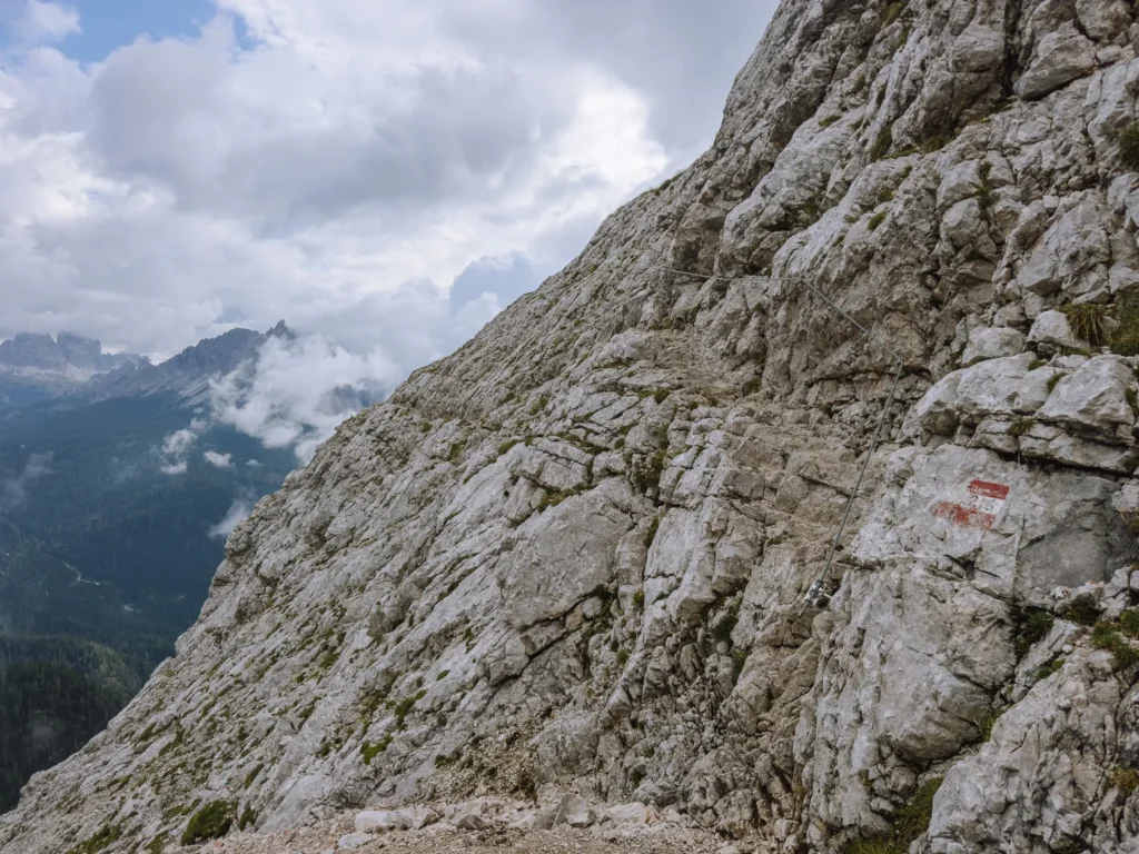
Navigation on the more challenging Forcella Marcoira route (orange on the map below) is also easy to follow; however, the path on the scree section is a little indistinct.
We have marked the parking locations, as well as the trails and rifugios, on the map below.
Click on the top right corner to open our map in your Google Maps app. Click the star next to the title to save it to your Google account.
Lago di Sorapis There & Back Hike
This is the easiest and quickest way to Lago di Sorapis.
- Distance: 11.5 kilometres
- Duration: 4 hours
- Elevation: 430 m
- Difficulty: Medium
Getting to the Lake
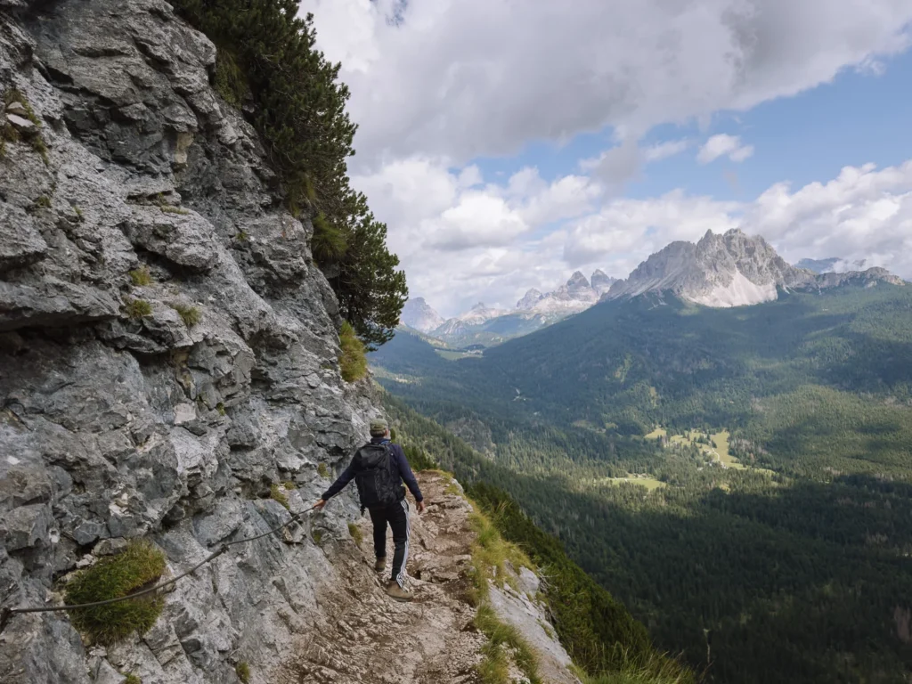
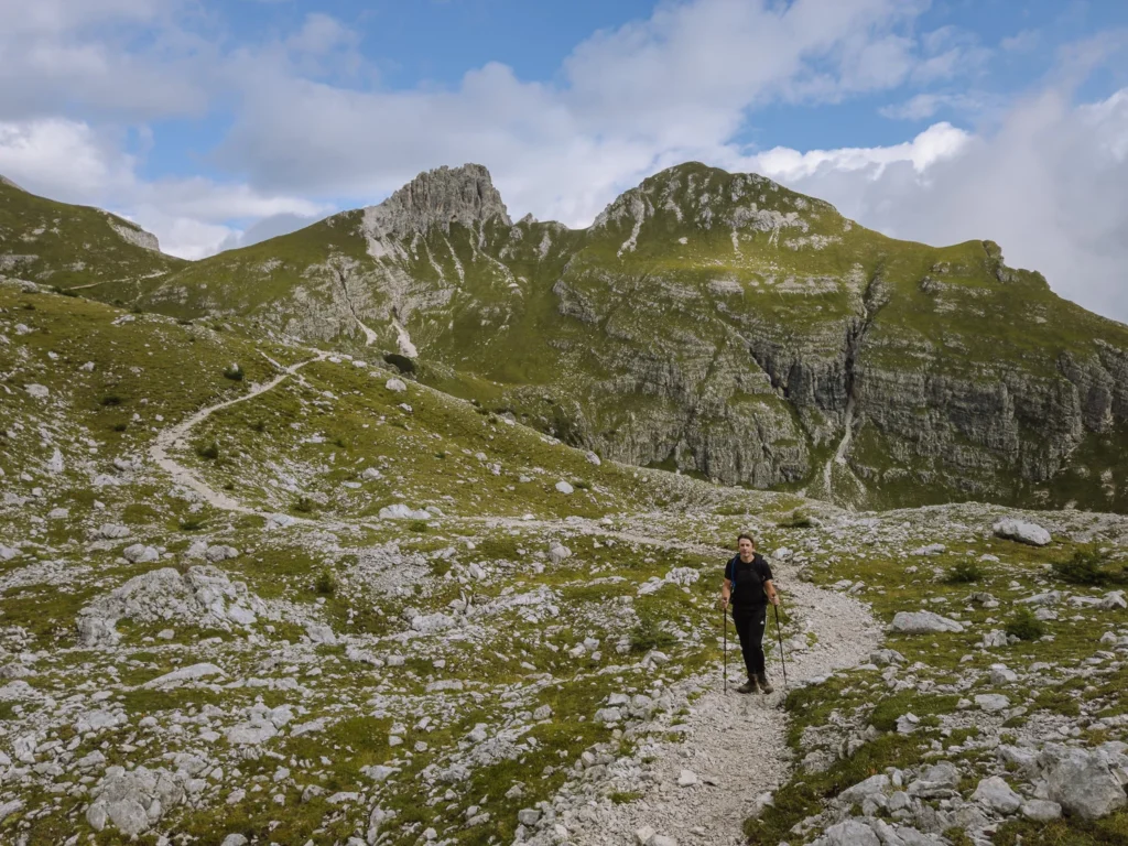
From Passo Tre Croci, the route to the lake is via Path 215. It is clearly marked from the road and easy to follow.
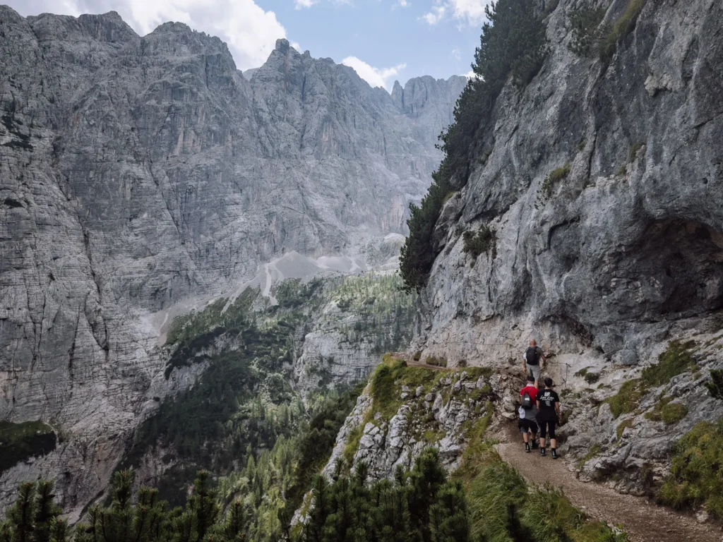
The walk begins gently, cutting through a pine forest. The peaks of Monte Cristallo and Piz Popena emerge through the foliage.
Shortly after crossing a dry river of rubble, the trees clear, and views open up to a panorama, including the unmistakable form of Tre Cime standing in the hazy distance.
After an hour or so, the path ascends via a metal staircase. Following this, there are two sections where the path crosses a narrow ledge with cables to hold onto for support. There is also a relatively narrow section without cables.
The ledges are about a 1 meter wide, so unless you have a very bad fear of heights, they should not be a problem.
The remainder of the walk to the lake is a bumpy path, where you will need to use your hands occasionally, but it is not technically challenging.
Just before reaching the lake, there is a junction. Ignore the left turn signed to Rifugio Vandelli, and instead turn right to reach the lake.
Around the Lake
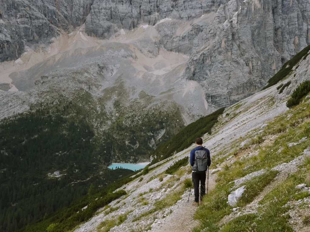
It should take around 2 hours to reach the lake, and the best views are as you arrive.
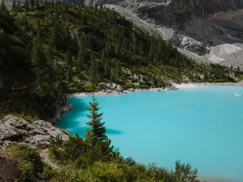
An impenetrable wall of rugged rock frames the turquoise waters on the far side. On the near side, there are large boulders and a natural terraced area where you can sit and soak it all in.
It’s worth making a loop of the lake. The far end has a different type of vegetation, and on the walk back, you are tucked under the mighty walls of the mountains. The loop around the lake is 1.7 km and takes about 40 minutes.
Return Hike
To return, follow Path 215 back the way you came.


What Is the There & Back Trail Like?
The first time we did Lago di Sorapis was in June 2019. We just completed the hike again in August 2025, and the trail felt quite different.
Firstly, Lago di Sorapis has become very popular over the last few years. The volume of people hiking the trail has, in effect, polished the rocks. Therefore, it can be very slippery underfoot in some areas. Please wear shoes or boots with a good grip.
The path feels particularly slippery on some of the sloping narrow ledges. Handholds are provided, so it’s safe when undertaken with care.
However, with so many people, you have to wait for your turn to cross, and if you have a fear of heights, it’s exacerbated by the jostling as queues back up.
You will not only need your hands on the cabled sections, but there are also a few big steps where using your hands is helpful.
The trail is clearly marked and very easy to follow. It is a medium challenge, made trickier by the number of people on the trail. Try to hike early in the morning or late in the afternoon / evening.
Lago di Sorapis via Forcella Marcoira
This is a challenging hike for experienced hikers.
- Distance: 15.7 kilometres
- Duration: 5.5 hours
- Elevation: 747 metres
- Difficulty: Challenging
Return via Forcella Marcoira
This challenging route takes the high mountain pass over the Forcella Marcoira saddle and has far fewer hikers than the regular out-and-back route.
It is a much more demanding trail and should only be undertaken in good conditions by experienced hikers.
To return via this route, leave the lake heading back the way you came along Path 215. After about 10 minutes, turn left on Path 216 signed to Ciadin del Loudo.
The narrow trail now climbs steeply. Ascending 400 metres in about an hour, it’s a long slog that requires some short scrambling. You’ll need to use your hands in a few places.
Upon reaching the top of the shoulder, there is a short zigzag section descending the other side. Part of it is assisted with metal handrails, but does not feel too exposed.
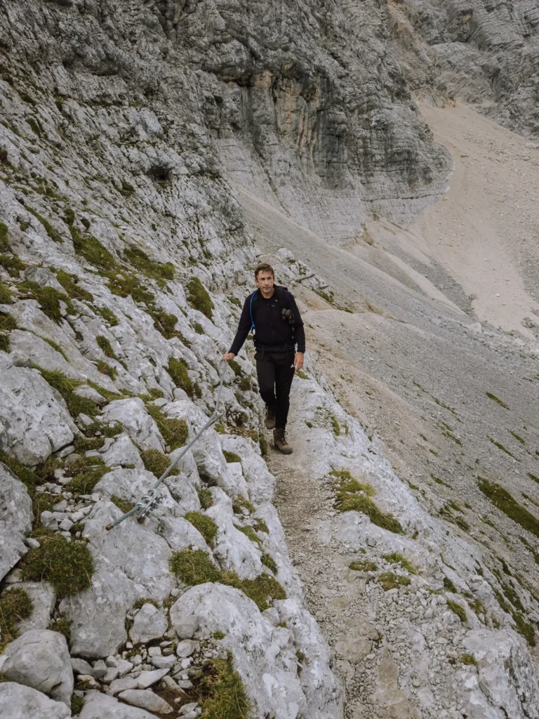
The zigzags end at a narrow ledge which is about 1-2 feet wide. The first section is unaided, but as it narrows, an invaluable metal cable offers support. Despite the steep drop on your right, the path is flat enough and wide enough to feel relatively safe. Even if it looks rather terrifying!
The ledge is only about 30 metres long and is all over in under a minute.
After navigating the ledge, the path drops into Ciadin del Loudo, a large grassy basin where we were lucky enough to spot some Alpine Ibex.
At the opposite side of the basin, you’ll ascend to the highest part of the walk Forcella Marcoira (2,307m).
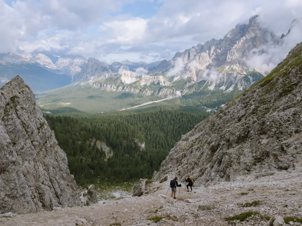
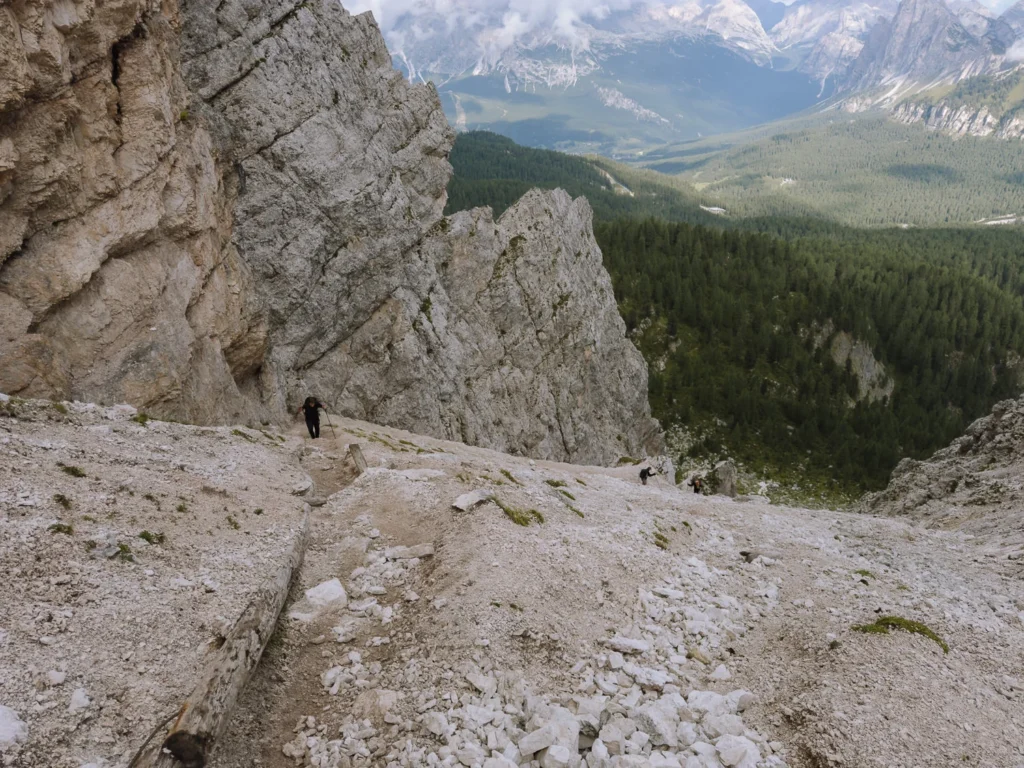
From here, the path makes a very steep descent down a rocky gully. This is the most challenging part of the walk, and you’ll need to take extra care. There is a large amount of loose rubble and slipping is easy. Try to follow the path signs as much as possible (it’s the easiest route down), and take your time.
After the gully, the path cuts across a scree field with a less steep descent.
Shortly, Path 216 reaches a junction. Turn right onto Path 213, a relatively easy trail that descends through the trees and returns to Passo Tre Croci.
What’s the Trail Like?
The start of this return route on path 216 is a bit of a relentless uphill slog. It requires the use of hands to get over tree stumps and the odd boulder. However, there is nothing technically challenging.
The narrow ledge is on a very stable path with secure cables for most of the length (around 30 metres). Providing you are OK with heights, this section should be no problem at all.
In our opinion, this ledge was easier than the ledges on the main Lago di Sorapis trail. It was flat and solid, and the cables felt very secure. Most importantly, however, there was no one else on it!
The descent via the rocky gully is challenging. The path is very steep and rocky, making it difficult to find your footing. At times, the path is made of loose rubble and gravel; other times, there are large boulders to get over or around.
It is very important to wear proper hiking boots or shoes with a good grip. Poles (that can be stored in a backpack) are also very helpful across the scree slope.
We recommend this route only for experienced hikers.

Clockwise or Anticlockwise
We find the difficult scree section and rocky gully on the Forcella Marcoira much easier going uphill rather than downhill.
Therefore, we recommend completing the challenging circuit in an anti-clockwise direction. Start at Passo Tre Croci, and follow Path 213 signed to Forcella Ciadin / Marcoira. At the junction with Path 216, turn left (signed to Forcella Marcoira) and ascend the scree slope and rocky gully.
Cross the Ciadin del Loudo basin, and finally descend to the lake by joining Path 215 for the final section.
This is the route we took last time we hiked Lago di Sorapis, and we loved it. The route up to Forcella Marcoira was a challenge but achievable, and we only saw two other people on the trail until we reached the (very busy) path 215.
To return, follow path 215 back from the lake, completing a circular hike.


Facilities at Lago di Sorapis
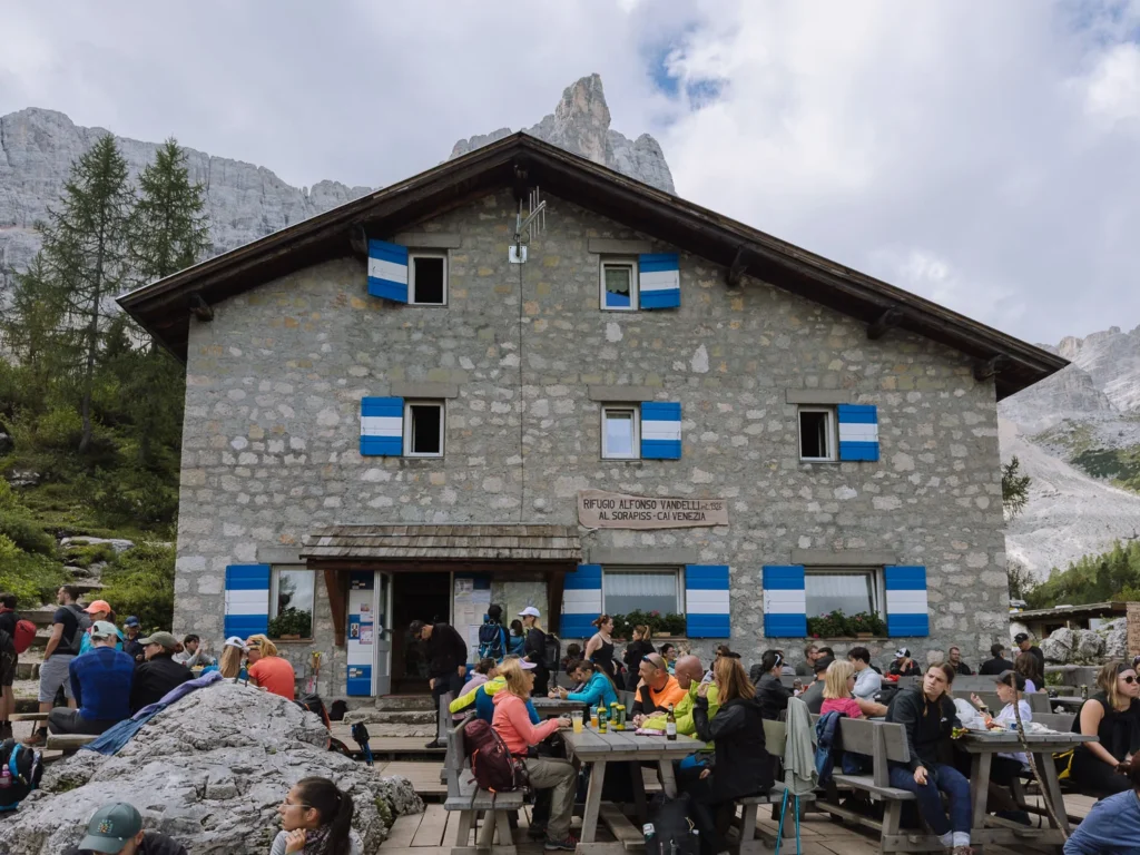
There is a bar and a rifugio (Rifugio Vandelli), a short distance from the lake.
You can have lunch at the rifugio during the summer months or grab something to eat from the bar.
There are toilets at the rifugio.
Neither the bar nor the rifugio has a view of the lake, and being completely packed on the day we visited, it didn’t quite have the amazing atmosphere of the other rifugios in the Dolomites.
We would recommend taking lunch with you to have in front of the lake.
The other option is to stop for lunch and a drink at Rifugio Baita Son Zuogo at the end of the hike. This rifugio is located on SR48, near the parking area. It has excellent tiramisu, a full lunch menu and wonderful views of the mountains.

Where to Stay?
The best place to stay to do the Lago di Sorapis hike is Cortina, which is 10 kilometres from Passo Tre Croci, where the hike begins.
It’s a charming town with a good range of facilities and public transport connections. You can read more in our Cortina d’Ampezzo guide.
The other option is to stay in Dobbiaco, which has a little less going on than Cortina. However, you may find more affordable options, especially during peak season. Dobbiaco is around a 30-minute drive from Passo Tre Croci.
Here are a few hotel recommendations from us:
- Al Larin Hotel (Cortina) – A Simple but clean budget hotel just one mile north of Cortina.
- Hotel de Len (Cortina) – Rural contemporary hotel with a minimalist design and strong sustainability credentials. There’s a wellness centre and excellent restaurants.
- Hotel Rosengarten (Dobbiaco) – Family-run property in the centre of Dobbiaco with a traditional restaurant and excellent views.


Best Time to Hike the Lago di Sorapis Circuit
We recommend hiking to Sorapis Lake in early July or September.
The crowds are less than in the summer months and the snow on the tops should have cleared, making the high return via Forcella Marcoira possible.
The best weather is in the summer months of late July and August, but it is also the busiest time. We visited in late August, and it was extremely busy. If possible, avoid the peak season as much as you can.
The views are great at all times of the day, but in peak season, try to leave early or late to miss the crowds and get a parking spot.


What to Take on the Hike
Hiking Boots: The full circuit is reasonably long and the ascent and descent from the pass requires some scrambling. For this one, we suggest wearing proper hiking boots (we use something similar to these).
Hiking Poles: We’re recent converts to hiking poles and for this walk, they make the ascent or descent via the steep rocky section much easier. We use the trusty Leki Sticks.
Waterproofs: Weather conditions on the walk can change dramatically, and rain is common in the afternoon. Make sure you take a waterproof like this one.
Sunblock/Hat: Since much of the walk is not in the shade, bring sunblock and a hat on hot days.
Lunch/Snacks: This is a long hike, and Rifugio Vandelli doesn’t offer views of the lake, nor is it open all year round. Therefore, bring your own lunch and snacks with you.
Water: Make sure you have plenty of water. We used one of these hydration packs, which makes it much easier to stay hydrated on the trail.
Maps: The main route is well-marked, but if you are taking the route via Forcella Marcoira, make sure you have an online map with you.
Drones: Drones are not permitted at Lago di Sorapis, so save the extra weight in your rucksack and leave it behind.


More Dolomites Guides
- Read our first-timer guide for visiting the Dolomites with practical information.
- Try one of our favourite hikes in the Dolomites.
- Where to stay in the Dolomites has our pick of the best areas.
- Cortina d’Ampezzo is one of the most popular places to base yourself in the Dolomites.
- Find out what’s good to do around Val Gardena.
- Read about more beautiful places to visit in the Italian Alps.
- How to visit Lago di Braies covers all the information you need to know.
- Read our complete guide to hiking Tre Cime – the best hike in the Dolomites.

reader-supported
When you buy through links on our site, we may earn a small affiliate commission at no extra cost to you.
Thanks for your support // Paul & Mark
Wow ! The hike is definitely not the easiest, but I hope it is not too difficult for an average fit person. Cause that view is stunning ! Love the photos you shot, especially the ones by the lake ! I’m adding this to my bucket list ! =)
Hi Jeremy, For an averagely fit person, it is not a problem. You just need to give yourself plenty of time to take breaks, refuel at the rifugio and have some snacks and plenty of water with you. Hope you get to go some time and if you do, let us know how it went! Good luck.
Your photos are incredible! The water is truly stunning and those are amazing views. It seems like a difficult hike, but definitely worth it. Is it 4 hours and 45 min roundtrip or one way?
Summer
https://travelingsummer.com
It was a beautiful time to go, because there was still snow about but the trail was clear. 4 hour 45 minutes round trip. So challenging but set off early and you have plenty of time for a fun day out.
I love your post on hiking the Lago di Sorapis; it’s very inspiring! I also liked how you showed the difficulty level. Since I’m still an amateur hiker, that information is precious. Outstanding photos by the way but I’m sure you already know that. 🙂
Thanks very much. We do love a hike! The walk to the lake itself is straightforward, just the trip back over the top that is more challenging. Hope you get the chance to go.
Oh my gosh, you do so many incredible hikes. Italy is just amazing all around anyway, but I love how you’re presenting things most of us would never see otherwise. You’re making me want to pull my hiking boots back out of my closet. I’d love the chance to tackle that hike.
Hope you get the chance, it is a winner. And I agree about Italy. If I was restricted to only traveling to one country all my life, Italy would be it.
The view of the trail is so gorgeous. I have never seen such a beautiful lake although I have trekked a few high altitude lakes in Himalayaas. Would love to hike here.
I’d love to hike in the Himalayas, very much on our list.
I love places that can only be reached by hiking. They always tend to be less crowded. Lago di Sorapis is one place I haven’t heard of yet but one that I would definitely like to visit. Perhaps my upcoming autumn trip to Italy will be a great chance to do so.
Yes, I agree, feel like you’re a bit more out in the wild. Hope you make it to the Dolomites on your trip to Italy, it’s amazing.
That is indeed a beautiful hike, and sceneries are wonderful! As mountaineers and hikers ourselves, we would definitely love it here. Is there a longer route that requires you to set camp? And if there is a longer route, are there established camp sites? Or is the route just for day hikes only? And another thing…those cliffs are great for rock climbing. Is there a rock climbing scene/outfitter nearby?
There isn’t a specific longer route that includes camping, but I’m sure you’d be able to make one up. There are plenty of rock climbing setups in Cortina which is nearby, but rock climbing isn’t allowed at Lago di Sorapis.
Although I am coming from neighboring Croatia, I haven’t visited the Italian Dolomites yet. But as a huge nature lover, I can’t wait to check them off my bucket list. The scenery is out of this world! And your photos are marvelous!
It is amazing. You’ll have to get over to the Dolomites, next time you get the opportunity.
The vibe of Dolomite trail is really excellent. It’s great that the only way to reach the lake is to hike. The hike looks very interesting, which is evident from your pictures. You have detailed the route plus have given a fair idea of the time. I really value the tips you have added later.
Hi Shreya, Glad it’s helpful. Hope you get the chance to hike it yourself. Good luck.
The hike to Lago di Sorapis is really beautiful and even when it starts from forest path is also very appealing. It is good that you took that return path 216 for lovely views at Forcella Marcoira.
It was a great walk. Thanks a lot for your comment. Sounds like you enjoyed it too.
Hi! I really enjoyed this article! But I have a big question: do you have any idea if it is ok to do something like this in February? I am a bit afraid of going in the winter but it’s the only time I have.
Thank you very much!
HI Francesca, Sadly I think it is highly unlikely that you’ll be able to walk this route in February. It is likely to be deep in snow and even if the lower parts have been cleared the ledges would be treacherous. Hopefully’ you’ll find another time to visit. Thanks for your comment and good luck.
My goodness, I can’t get enough of these beautiful pictures. The Dolomites really have stolen my heart over the years. However, I’ve never hiked such a challenging hike as this one. The views are magnificent though. Maybe something to keep in mind for my next trip down there…
Hope you get the chance to go and do the walk. If you do let us know how you it went. Thanks
Thanks for your informative post!! I like your photos too 🙂
Your photographs are amazing! Those are breathtaking vistas, and the lake is very beautiful. Although it appears like a challenging climb, it is worthwhile.
By the looks of it, you went in May? I’m wanting to go first week of May next year, is the hike doable at this time?
Hi Laecy – That’s a tricky one and it really just depends on the conditions. When we were there in early June there was still quite a bit of snow on the trails, so it’s possible there is too much snow in early May. However, it’s not impossible. You’re best bet would be to keep an eye on the conditions before you leave. It probably safe to say the high pass on the return leg would not be possible in early May.