Thórsmörk is a remote wilderness area in Iceland’s Highlands. It has some of the best hiking in the country, but getting there is tricky. This guide explains how to visit and has maps and instructions for the best hikes.
By: Paul Healy | Last Updated:
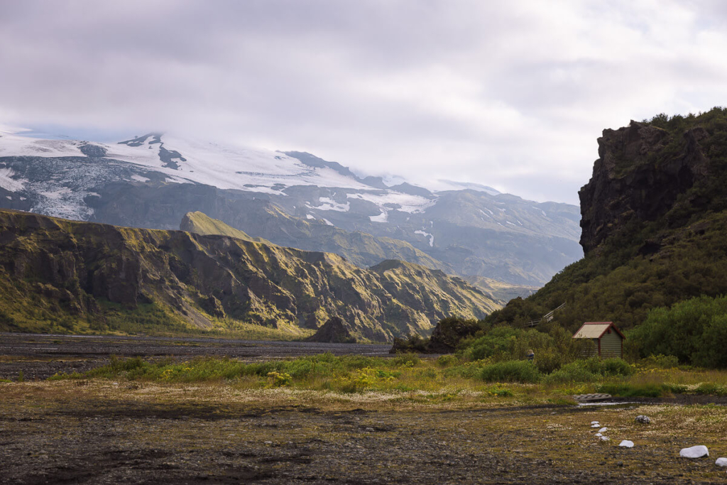
Thórsmörk (Þórsmörk Nature Reserve in Icelandic and named after the Norse god Thor) is a remote area in the Iceland Highlands, where three valleys converge under three imposing glaciers, forming a dramatic wilderness of spectacular scenery.
We spent two fantastic days exploring the area, completing several hikes, and were blown away by the views. There are several reasons why we loved visiting Thórsmörk.
Firstly, getting there was an adventure. It involves making your way along the F249. This tricky mountain road has to ford multiple rivers, the largest of which is the Krossá River. It can only be done in specially adapted vehicles or by taking the bus. Either of which is thrilling.
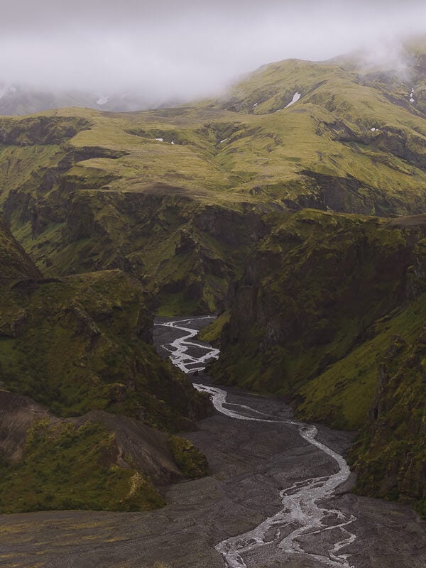
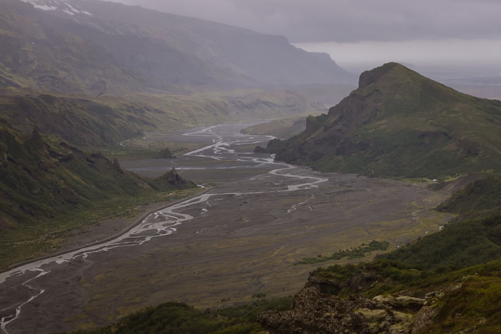
Secondly, we loved Thórsmörk’s scenery. Huge moss-covered mountains are dwarfed by even bigger glaciers, and the fast-flowing rivers cut mesmerising patterns into swathes of black rock.
Thirdly, Thórsmörk has some truly great hikes. Some are easy, lasting only one or two hours and stopping at excellent viewpoints, while others are longer and head along tricky trails to several incredible panoramas. Quite simply, hiking here is one of the best things to do in Iceland.
Thórsmörk is only accessible in the summer months (except for super-jeep tours), and you’ll need to plan ahead to make the most of your experience.
Whether you’re visiting Thórsmörk on a day trip or staying longer, here’s everything you need to know.

Where Is Thórsmörk?
Thórsmörk is a remote region at the southern end of Iceland’s Highlands, about 150 kilometres from Reykjavik.
It is wedged between 3 mighty glaciers, Mýrdalsjökull, Tindfjallajökull and Eyjafjallajökull, and surrounded by the Krossá, Þröngá, and Markarfljót Rivers.
Unless you hike into Thórsmörk, the only access is via the F249 Þórsmerkurvegur mountain road. The closest town and fuel station is Hvollsvöllur, but you can also visit Thórsmörk on a day trip from Reykjavík.
Layout of Thórsmörk
Thórsmörk lies on either side of a dead-end valley and is cut in two by the Krossá River.
It has three different accommodation options. Two of them, Langidalur and Volcano Huts (Husadalur), are north of the Krossá River, and the third, Básar Huts, is south.
The Krossá Rover is notorious for sudden changes in its water level due to the vast glaciers that feed it. The river can be very dangerous to ford, but in summer, a moveable pedestrian walkway (see photo below) allows you to cross between Básar Huts (south of the river) and the other two camps (north of the river).
Most of the best day hikes are north of the river and leave from either Langidalur or Volcano Huts.


Thórsmörk Map
The map below helps explain the layout of Thórsmörk.
We have added the hikes we recommend in this guide, which are coloured to match the colours of the trail markers in Thórsmörk.
The brown line shows the F249 Þórsmerkurvegur mountain road, including the tricky river crossings.
Click on the top right corner to open our map in your Google Maps app. Click the star next to the title to save it to your Google account.
How to Get to Thórsmörk
Although only around 30 kilometres from the Ring Road, Thórsmörk is notoriously difficult to get to.
You can choose between four options: drive yourself, take the Highland bus, get a private super jeep tour, or hike in.
Option 1 – Driving to Thórsmörk
The only road into Thórsmörk is the F249 Þórsmerkurvegur mountain road.
F-roads are unpaved gravel tracks that are not regularly maintained and often include river crossings, driving over sand and very bumpy conditions. By law, only 4×4 vehicles can drive on the F-roads. You can read more about them on our comprehensive guide to driving on the F-roads in Iceland.
The F249 is one of the most challenging mountain roads to drive. It has many fast-flowing rivers to ford, and the depth of the rivers can change quickly.
We strongly advise you NOT to drive to Thórsmörk unless you have a large 4×4 and plenty of experience crossing deep rivers. Even then, only attempt to get to the movable walkway near Basar Huts, and not to Langidalur Camp or Volcano Huts.
Even if you feel confident enough to make the drive, check your rental car agreement. Many firms specifically state you cannot drive the F249 in their cars.


Driving to Básar Huts
To drive to Básar Huts campsite (south of the Krossá River) there are two tricky river crossings – over the Steinsholtsá and Hvanná rivers. In normal conditions, you will need a large 4×4 and good experience crossing rivers.
Once at Básar Huts, you can park the car and use the movable walkway to cross the Krossá River and access the hiking trails on the other side.
Driving to Langidalur or Volcano Huts
To drive to Langidalur and Volcano Huts (north of the Krossá River), you’ll not only need to cross the Steinsholtsá River (and Hvanná for Langidalur), but you’ll also need to cross the Krossá River.
One of the fastest-flowing and most unpredictable rivers in Iceland, the Krossá should be crossed only by specially modified 4×4 vehicles and experienced drivers.
We have hired a medium 4×4 on all our trips to Iceland and have had a great time taking the F-roads to many great places in the country’s Highlands. However, driving to Thórsmörk is not safe in this size car or with our level of experience.
The image below is a medium-sized 4×4 that got stuck in one of the more minor crossings getting to Thórsmörk.

Option 2 – Highland Bus to Thórsmörk
During the summer months, a modified bus makes the difficult journey down the F249.
Specially designed to cope with the rough territory and fast river crossings, it’s a safe, easy, and reliable way to get to Thórsmörk.
You can take the bus from Reykjavík (4 hours), Hella (2 hours), or Hvollsvöllur (1 hour, 30 minutes) and be dropped off at any of the three campsites: Volcano Huts (Husadulur), Langidalur, and Basar Huts.
Reykjavík Excursions runs two services daily in either direction, costing roughly $80 USD per person return to Hvollsvöllur.
The first bus arrives in Thórsmörk around 11 am and the second around 6 pm. The buses depart Thórsmörk mid-afternoon and late in the evening.
Getting Between the Campsites
The bus journey between Volcano Huts (Husadalur) and Langidalur Campsite can take 45 minutes to 1 hour because it has to cross the Krossá River twice (see brown route on map below).
Walking between the two campsites only takes 20-30 minutes, so it is often best to get off at whichever is the first stop and start exploring from there.
We have recommendations for which buses to book and how to organise a day trip, further down in this post.


Option 3 – Super Jeep Tour to Thórsmörk
Super jeeps are specially modified vehicles with massive wheels that are designed to navigate Iceland’s challenging conditions. It’s not the cheapest way to see Thórsmörk, but it does let you reach places that aren’t accessible in a normal vehicle.
Tours range from 6 to 10 hours, are privately organised and can be tailored to the groups. Most allow short 1-to-2-hour hikes to some of the most scenic places, while others allow 3 to 4 hours to reach higher elevations.
This super jeep tour takes up to 4 people, helping reduce the cost.

Option 4 – Hike into Thórsmörk
Two excellent point-to-point hikes begin or end in Thórsmörk. They are considered two of the best hikes in the world.
Laugavegur Trail // The 3-day Laugavegur Trail from Landmannalaugar covers some of the most unique and spectacular landscapes in Europe. This guided hike tour includes all meals and accommodation, an expert Icelandic guide and luggage transportation – so you only need to carry what you need for the day.
Fimmvörðuháls Hike // This 25.7-kilometre trail, known as the Fimmvörðuháls Hike, runs between Thórsmörk and Skógar. It starts at Skógafoss, one of Iceland’s most iconic waterfalls, and provides fantastic scenery circumnavigating the base of two of Thórsmörk’s glaciers, Eyjafjallajökull and Mýrdalsjökul. The walk takes between 8 and 10 hours and is not to be undertaken lightly.

Best Hikes in Thórsmörk
We had great fun hiking the trails in Thórsmörk. Most trails begin and end at one of the three campsites: Volcano Huts, Langidalur Huts, and Básar Huts.
Here’s a breakdown of the different walks. Each has its own coloured markers to help you find the route.
1. Mount Valahnúkur Hike
The summit of Mount Valahnúkur probably has the finest views in Thórsmörk. Standing on its 465-metre peak, you can look both ways down the Krossá Valley as the river twists and turns through the black gravel.
There are also great views of the deep canyon cut by the Hvanná River. The 360-degree views capture jagged green mountains and on a clear day, all three glaciers. It’s the best way to get an overview of the valley.
It’s a relatively easy hike with a clear path that proceeds straight up Mount Valahnúkur with steps, then down around the other side to Langidalur. If you are short of time and only do one walk, this is the one.
MOUNT VALAHNÚKUR ROUTE
Volcano Huts – Mount Valahnúkur – Langidalur – Volcano Huts
MOUNT VALAHNÚKUR DETAILS
Distance – 2.5 miles (4.3 kilometres) | Time – 1 hour 45 minutes | Difficulty – Easy | Markers & Map – White


2. Thórsmörk Highlights Hike
This is a lovely circular hike in the Húsadalur Valley that heads through birch trees and up to the foothills of the Tindfjöll mountains. It then ascends to the Slyppugil Ridge for fine views over Slyppugil Canyon before bending back down through the trees to Langidalur Campsite.
It’s an interesting and varied hike that includes lots of different types of scenery from shady forested paths to impressive mountain vistas. Get an appreciation for the Thórsmörk landscape that feels like an oasis hidden behind the notorious Eyjafjallajökull glacier.
THÓRSMÖRK HIGHLIGHTS ROUTE
Volcano Huts – Thórsmörk Highlights Red Path – Slyppugil Ridge – Langidalur – Volcano Huts
HÓRSMÖRK HIGHLIGHTS DETAILS
Distance – 5.25 miles (9.0 kilometres) | Time – 3 hours 15 minutes | Difficulty – Easy to Medium | Markers & Map – Red
3. Tindfjöll Circle
This is a wonderful, if slightly challenging circuit, around some of the best scenery Thórsmörk has to offer. The route heads east from Langidalur along the north edge of the Krossá valley.
At Slyppugil Hut, the trail turns left and heads up the Slyppugil Valley. It slowly rises before bending right and following the edge of a dramatic and precipitous canyon. The path here is narrow, with steep drops on one side and the towering face of Tindfjöll Mountain on the other.
Exiting the canyon, the path turns right and reaches a glorious viewpoint before winding its way along the edge of a ridge and then dropping (steeply at times) back to the valley floor where you follow the river back to Langidalur.
This is a medium to challenging hike with more ascent and trickier paths than the first two. It helps if you have a head for heights and good grip on your shoes.
TINDFJÖLL ROUTE
Langidalur – Slyppugil – Slyppugil Canyon – Tindfjöll Viewpoint – Krossá River – Langidalur
TINDFJÖLL DETAILS
Distance – 5.25 miles (9 kilometres) | Time – 4 hours, 30 minutes | Difficulty – Medium | Markers & Map – Orange


4. Rjúpnafell Hike
This is a challenging extension to the Tindfjöll Circle and involves climbing the 964-meter-high peak of Rjúpnafell. The dramatic summit is ascended by tight zigzags up its very steep face. The views are magnificent but it’s a very challenging hike, both physically and mentally.
You need to be very cautious on this hike as the path is very steep and indistinct in places. Do not attempt the ascent if the top is covered in cloud or if it’s windy when you get to the base of the mountain. This is not a hike for anyone with a fear of heights. It’s a good idea to check the conditions at the information desk at Langidalur before you set off.
Add 3 to 4 hours to the Tindfjöll Circle to complete the Rjúpnafell hike.
RJÚPNAFELL ROUTE
Langidalur – First half Tindföll Circle – Rjúpnafell – Second Half Tindfjöll Circle – Langidalur
RJÚPNAFELL DETAILS
Distance: 9.75 miles (16 kilometres) – Time: 8 hours – Difficulty: Challenging

5. Merkurrani Plateau Hike
This is an easy hike that not only gains wonderful views over Krossá from the top of the plateau but also descends to the Markarfljót River as it cuts its way through the black riverbed.
The trail leaves from Volcano Huts and follows the white posts towards Mount Valahnúkur, but just before the summit, turn right and follow the green posts across the plateau. Wonderful views over the cliffs are revealed before the path drops down to the river and heads back to Volcano Huts.
MERKURRANI PLATEAU ROUTE
Volcano Huts – Towards Mount Valahnúkur – Merkurrani Plateau – Markjaflot River – Volcano Huts
MERKURRANI PLATEAU DETAILS
Distance – 2.5 miles (4.25 kilometres) | Time: 1 hour 45 minutes | Difficulty – Easy | Markers & Map – Green
6. Stakkholtsgjá Canyon Hike
Stakkholtsgjá is a 2-kilometre canyon in Thórsmörk with steep-sided moss-covered walls and a series of streams, culminating in a beautiful waterfall that was used in Game of Thrones.
The walk up the canyon is not particularly challenging, however, there are several streams to cross and you should expect to get wet, at least once.
It takes around 1-hour to walk from Básar Huts to the start of the Stakkholtsgjá canyon hike, then about another 1.5 hours to reach the end of the canyon. If you are coming from Langidalur, you’ll need to cross the moveable walkway over the Krossá River then walk down to the start of the canyon.
The issue is that you will somehow need to get across the Hvanná River. The highland bus may drop you off, otherwise, it might be better to organise a private tour through Midgard Adventure.
STAKKHOLTSGJÁ CANYON ROUTE
Stakkholtsgjá Canyon entrance to the end of the canyon and back
STAKKHOLTSGJÁ CANYON DETAILS
Distance – 1.75 miles (3 kilometres) | Time – 1 hour 30 minutes | Difficulty – Medium | Markers & Map: Purple
7. Fimmvörðuháls Hike
This is one of the great hikes of Iceland. Over the course of 15 miles and 1,400 metres of ascent and descent, the trail passes 25 waterfalls, two glaciers, one volcano, and miles and miles of rock.
Most people start at Skogáfoss on the south coast and hike over the ridge between Mýrdalsjökull and Eyjafjallajökull glaciers, before descending into Thórsmörk.
If trying it all in one go sounds a bit too challenging then you can break it in two and spend the night at Baldvinsskáli hut. It accommodates 16 people, and you’ll need to make a reservation in advance.
FIMMVÖRÐUHÁLS ROUTE
Skógar – Baldvinsskáli –– Fimmvörðuháls – Básar Huts in Thórsmörk
FIMMVÖRÐUHÁLS DETAILS
Distance – 15.5 miles (25 kilometres) | Time – 10 hours | Difficulty – Challenging


8. Laugavegur Hike
The most famous multi-day hike in Iceland and chosen as one of the “20 Best Hikes in the World” by National Geographic, the Laugavegur trail crosses the highlands from Landmannalaugar to Thórsmörk.
Over the course of 3 days, the hike delivers some outstanding scenery, including lava fields, colourful rhyolite mountains, canyons, glaciers and active volcanoes.
It can be difficult to coordinate accommodation, so this is a good hike to do as an organised tour. Even if you don’t do this multi-day hike, try to visit Landmannalaugar on your Iceland itinerary.
LAUGAVEGUR ROUTE
Landmannalaugar – Hrafntinnusker – Álftavatn – Emstrur – Langidalur in Thórsmörk
LAUGAVEGUR DETAILS
Distance – 34 miles (55 kilometres) | Time – 3 days | Difficulty – Challenging


Accommodation & Facilities in Thórsmörk
It’s easy enough to visit Thórsmörk on a day trip (see itinerary below). But to explore more, you may want to stay overnight.
There are three places to choose from: Volcano Huts, Langidalur or Basar Huts.
Volcano Huts
Volcano Huts (Húsadalur bus stop) has glamping tents, single or double cabins with shared bathrooms, cottages with bunk beds and dorm rooms. You can also camp on site. The cabins and cottages tend to book up well in advance, and it is often running at capacity over the summer months, so book early.
There is a restaurant on site which serves breakfast from 8am -10am, soup buffet from 11:30am to 3pm and dinner from 6pm to 9pm. Coffee, cakes, muffins and alcohol is available throughout the day.
There’s an information desk with knowledgeable staff who can provide information about the different hiking options.

Langidalur Hut & Campsite
Langidalur Hut and Campsite occupies a beautiful setting on the edge of the Krossá River. There’s a hut that sleeps up to 75 people on two separate floors (bunkhouse style), a dining hall and a BBQ area. There’s space for camping and a toilet and shower block.
A small shop sells basic snacks (crisps, chocolate bars) as well as tea, coffee, and beer. The helpful staff will be able to provide information on hikes and mountain conditions.
The shop opens from 8am to 7pm and again from 8pm to 10pm. There’s no restaurant or café at Langidalur.
Básar Huts
Básar has huts accommodating 83 people as well as pitches for your own tent. There are gas stoves, grills and kitchenware as well as a shower and toilet block.
Básar is on the south side of the Krossá River but most of the day hikes start from the north side. So, you’ll need to get across the river on the moveable walkway which takes around 30 minutes. If you intend to do a lot of hiking in Thórsmörk, it’s generally more convenient to stay in Volcano Huts or Langidalur.

Day Trip to Thórsmörk
If you don’t intend to stay overnight in Thórsmörk, you can still see the best of the area on a day trip.
Make sure you book the first bus of the day. It should arrive in Thórsmörk around 11 a.m. Then, you can choose between booking the mid-afternoon bus, which leaves about 4 p.m., or the evening bus, which leaves about 8 p.m.
This gives you either about 5 or 9 hours to explore.
We suggest getting off at Volcano Huts (Husadalur) and beginning exploring from there. It has the best facilities (including the only restaurant) and the staff can help you plan your day.
Here are some suggestions for what you could fit in.
Thórsmörk 1-Day Itinerary
UP TO 2 HOURS
Hike up to Mount Valahnúkur and take in the view
UP TO 4 HOURS
Combine the Mount Valahnúkur and Merkurrani Plateau hikes.
UP TO 5 HOURS
Combine the Mount Valahnúkur and Thórsmörk Highlights hikes.
UP TO 7 HOURS
Combine the Mount Valahnúkur and Tindfjöll Circle hikes.
We highly recommend trying to spend as long as possible to see the area. On our latest visit, we took the morning bus to Husadalur / Volcano Huts (arriving at 10:30am), then hiked up Mount Valahnúkur (11:30am) for the spectacular view.
We ate a packed lunch at Langidalur (12:30pm), then hiked around the Tindfjöll Circle (5:30pm) and made our way back to Volcano Huts (6pm) where we had a couple of pints and some snacks while waiting for the evening bus back home (7:15pm).

When to Go to Thórsmörk?
The best time to go to Thórsmörk is from late June to early September when the snow has melted, the roads more accessible and the hiking at its best. The high ridges and glaciers that surround the valley trap the warm air, creating a strange micro-climate that keeps Thórsmörk warmer than most other areas in southern Iceland.
The F249 road to Thórsmörk is closed for most months of the year but usually opens from mid-June to early September.
Huts can be booked from the beginning of May to end of October, with tent pitches available from mid-June to mid-September.
The Highland Bus usually starts in early June and runs daily till mid-September.
Super jeeps can make the journey all year round, although hiking would be a challenge outside of summer.


What to Bring with You to Thórsmörk
- In spite of the micro-climate, the weather in Thórsmörk can change fast. As you will probably be hiking most of the day, bring waterproof jacket and trousers, as well as good quality hiking shoes or boots with a decent grip.
- Warm layers including a woolly hat and gloves are advisable.
- There is food available at Volcano Huts and a small shop at Langidalur but otherwise, it might be better to bring snacks and lunch with you.
- Water bottles can be filled up at all the campsites.
- Make sure you download our map onto your phone to help you get your bearings when you arrive.
Where to Get Supplies?
Apart from the shop at Langidalur and the café at Volcano Huts, there are no other facilities at Thórsmörk.
The best place to stock up is at the N1 fuel station in Hvollsvöllur, where the bus from Reykjavik makes a stop. The shop is well-stocked for snacks and premade sandwiches/pastries, but they don’t stock things like ham, cheese or bread to make your own sandwiches. You can also get a coffee to go.
Opening hours are from 7am to 10pm daily.

More Iceland Highland Guides
- All you need to know about driving the F-roads in Iceland.
- Explore the stunning Iceland highlands and get off the tourist trail.
- Enjoy breathtaking scenery on these incredible Landmannalaugar hikes.
- Read our complete guide to visiting Landmannalaugar.
- How to get to Thórsmörk – the Valley of the Gods.
- Should you self-drive to Askja?
- Our favourite Highlands location: Maelifell Volcano.
- Our guide to Kerlingarfjöll.
- Looking for remote accommodation? Here’s where to stay in Iceland.

reader-supported
When you buy through links on our site, we may earn a small affiliate commission at no extra cost to you.
Thanks for your support // Paul & Mark
Hello, thanks a lot for this ! I went twice already in Thorsmork (2003 and 2007), and had difficulties finding the paths. So now that I go back this summer with kids this time, I wanted to prepare, and you re one of the only blog to explain so well. I hope the paths are better indicated than before, and it looks so!
i have a question:
From Basar cabin
FIMMVÖRÐUHÁLS HIKE
We would just like to walk to a place where we can have a good view. Would you know how much it would take, and if it would be difficult? We could have 4 hours to spend, not more.
thanks!
Hello,
Sounds like you’ve got another great trip coming up. We loved Thorsmork such a great park of Iceland.
The trails were quite well-marked last time we were there, so maybe they have improved recently. Each of the hikes were color-coded making it pretty easy to know what trail you were on.
If you were to walk some of the Fimmvörðuháls hike from Basar Huts, you would probably start getting good views after about 30 minutes. However, we would recommend hiking to the top of Mount Valahnúkur which has some of the best views of the 3 valleys meeting at the centre of Thorsmork.
From Basar Huts, it’s a 9 kilometre walk with 350 metres of ascent to get over to Mount Valahnúkur and back. This will give you the best view of the area and you should be able to do it in under 4 hours with kids.
Have a great trip.
Paul.
This was so helpful and clearly explained. I found it difficult to find good information on this area. Thanks for the info!
Hi Paul and Mark,
I´m going back to Iceland for the third time, I love the country. I am doing the whole hike from Landmannalaugar to Skogar with friends and family and I have been to Throsmörk but your explanation is going to help me enjoy it much more. I´m very grateful for finding your page. I will follow you on Instagram.
Just wanted to say thanks.
Joe
Hi Joseph,
Thanks so much for letting us know. We love Iceland as well, there’s really nowhere quite like it. The hike from Landmannalaugar to Skogar will be incredible, I’m sure. Have a wonderful trip.
Paul.
This page, and the map especially, were so helpful on my recent Thorsmork trip. The huts didn’t have any maps to take with you on the trail and we would have gotten lost several times without your map. Thank you so much!
Hi Lisa, It’s great you found the post useful. We had the same issue when we were there. Took us quite a while to even find the beginning of the Tindfoll hike. Thanks for you comment. Mark
Great guide. Very infromative. I am going in two weeks time! Thank you!
Hi Paul and Mark,
I’m planning my first trip to Iceland and I’m even more excited to go there now I’ve found your blog.
The highlands attract me the most so I hope to spend most of the time there. We rent a 4×4 (Suzuki chimney) and also want to spend time in Thorsmörk. Do you have an idea where we can drive nearby to leave the car and travel on by bus or super jeep to thorsmörk?
Thank you very much for sharing, Renata
Hi Renate,
You can park at the N1 Gas Station in the town of Hvolsvöllur where the bus departs to Thorsmörk departs from. There is plenty of parking and and shop that sell some esentials for your day trip. The bus can drop you back there as well.
Have a great time, Thorsmörk is amazing.
Paul.
Really appreciate this article. We have one day to spend in Thorsmork and will have about 6 hours from what I can tell. I really want to hike the Tindfjoll circle hike – do you think this is cutting it too close? And would you recommend taking the bus to the Langidalur stop or Volcano huts (and same question for departure)? Thank you!
Hi Leah,
Glad you found it useful.
It took us 4.5 hours to do Tindfjöll, so think you should be fine with 6 hours.
In terms of the bus, the hike starts from Langidalur. However, when were were last there, the first stop on the bus was Volcano Huts, followed by Langidalur. It’s only a 20-minute walk between Volcano Huts and Langidalur, whereas the bus takes at least 45 minutes to 1 hour. So we go off at Volcano Huts and walked over to Langidalur.
After the walk, we caught the bus back from Langidalur. There’s a small cafe and some places to hang out while you wait.
It might be a good idea to check the bus timetables, or ask the bus driver, just in case they have changed the route.
Hope this helps.
Paul.
Thanks for this! It’s incredibly useful – especially the map! Can you please clarify – what is the blue line on your map? Thanks again!
Hi Adriane,
Thanks a lot, glad you found it useful. We had a great time visiting Thorsmork.
The blue line on the map is the path that connects the three huts: Volcano Huts to Langidalur to Básar Campsite.
Have a great trip.
Paul.