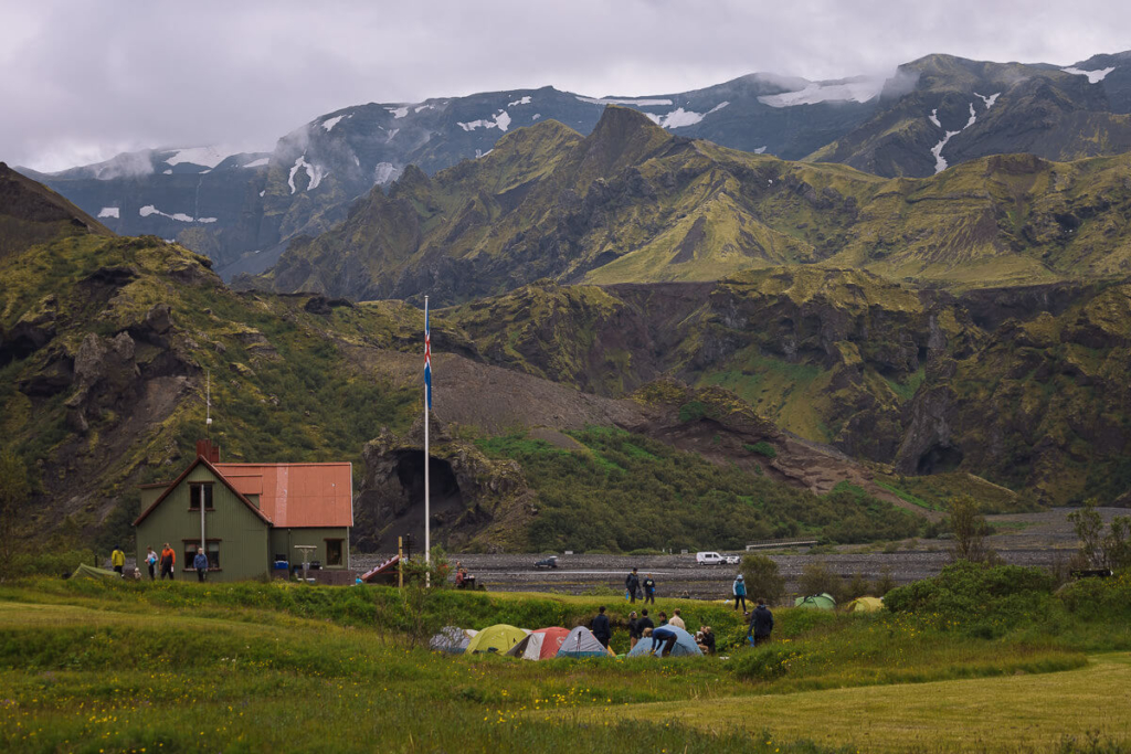
Landmannalaugar, deep in Iceland’s highlands, is a wonderland of colourful mountains, steaming sulphur vents and volcanic craters. Here is a breakdown of the best Landmannalaugar hikes.
By: Paul Healy | Last Updated:
Landmannalaugar effortlessly combines beauty and desolation.
Black jagged lava fields surround colourful red and green mountains; sulphurous vents rise through scarred earth and bubbling rivers meander volcanic craters.
Dotted throughout this dramatic scenery is a myriad of captivating hikes – full and half-day trails that take you into an otherworldly Icelandic experience.
It’s an amazing destination and one of our favourite places in Iceland. Mark and I regularly return to it.
With a couple of visits to Landmannalaugar under our boots, this guide is our selection of the best hikes in the area.
They range from a straightforward couple of hours, to more strenuous walks that will take most of the day and one epic multi-day experience.
To help with your planning, read our guide to visiting Landmannalaugar which includes maps and useful information.
We also have detailed instructions on getting to Landmannalaugar.

Map: Hiking in Landmannalaugar
The map below has an overview of the best hikes in Landmannalaugar. It’s a useful guide to get your bearings, but please follow the coloured signposts.
The ranger at the Landmannalaugar information hut can provide hiking advice and two maps: a comprehensive yet expensive map covering Landmannalaugar, Laugavegur, Thórsmörk & Fimmvörðuháls, or a cheap hand-drawn map for around 300 ISK.
If you are doing the low-lying easy walks in good conditions, the hand-drawn map will do. If you are hiking all day up the mountains, you may want the higher-quality map.
Make sure you have Google Maps or maps.me downloaded for the area onto your phone before setting off.
Click on the top right corner to open our map in your Google Maps app. Click the star next to the title to save it to your Google account.


Best Hikes in Landmannalaugar
1. Laugahraun Loop
- Distance: 4.3 kilometres (2.6 miles) loop
- Time: 1 hour, 45 minutes
- Elevation: 200 metres (+/-)
- Difficulty: Easy
For a short hike that covers many highlights at Landmannalaugar, the Laugahraun Loop is a great place to start.
In under 2 hours, you cross a lava field, amble past multicoloured mountains and head down a small canyon.
The path leaves the tourist information centre and rises onto the Laugahraun Lava Field (red markers). The trail requires a bit of concentration as the rock is hard and not always even, but it’s not long before you have dropped over the other side.
Following the trail up a small valley and across a moraine, you come to the base of Brennistensalda. Also known as the ‘sulphur wave’, this yellow and red mountain rises before you as steaming vents surround it.
The path skirts brown bubbling mud pots before meeting a junction of other trails.
Turn left (and follow the orange markers) heading back across the lava field.
From here, the green and blue rocks that cover Bláhnúkur’s flanks drop into a river that winds down the Graenagil Canyon (orange markers).
The path follows a bubbling river along the valley floor, and after just 1 hour and 45 minutes, you are back to where you started.


2. Brennisteinsalda (Sulphur Wave)
- Distance: 6.6 kilometres (4.1 miles)
- Time: 3 hours
- Elevation: 310 metres (+/-)
- Difficulty: Easy – Medium
Nicknamed the Sulphur Wave, Mount Brennisteinsalda is a colourful display of yellow and red slopes splattered with spots of blue ash.
The base is surrounded by black lava, in places covered with green moss.
This excellent hike is an extension of the Laugharaun loop in reverse. However, instead of walking around the eastern base of Mt Brennisteinsalda, this hike goes over the top.
The result is an even closer look at the multitude of colours as well as excellent views over the surrounding landscape.
Begin at the campsite and head up the Graenagil Valley, then across the western end of the lava field (orange markers).
Turn left onto the Laugavegur Trail (red markers) and then right to take the steep, short ascent up to the summit of Brennisteinsalda (white markers).
The views over the lava field from here are excellent.
The path (white markers) heads over the other side and drops gently towards Vondugil. It’s a great section of easy walking alongside a wide valley with great views over the rhyolite mountains.
Finally, reconnect with the Laugharaun Loop and take the path (red and white markers) over the lava field back to Landmannalaugar.


3. Bláhnjúkur Mountain (Blue Peak)
- Distance: 5.8-kilometre (3.6 miles) round trip
- Time: 3 hours 30 minutes
- Elevation: 380 metres (+/-)
- Difficulty: Challenging (steep ascents & descents plus a river crossing)
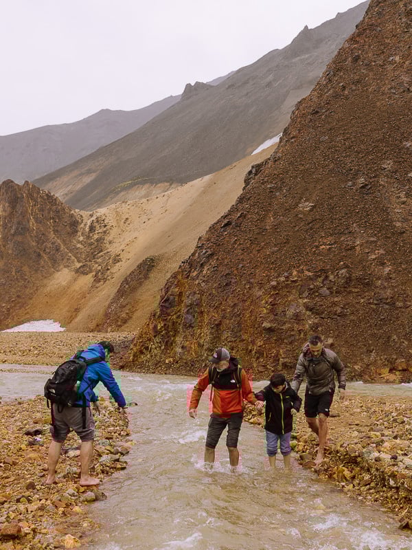
The hike up Bláhnjúkur Mountain (meaning “blue peak”) is the most challenging on this list.
There’s a steep ascent with a narrow path that has precipitous drops on both sides as well as a river that you may need to wade across.
But if you are up for the challenge it is the most rewarding hike in the area. The views are simply majestic.
From the campsite head south towards the entrance of Graenagil Canyon, cross the wooden plank over a small stream and head towards path that climbs steeply up a green hill (yellow markers).
As the path rises up a set of zig-zags, the green turns to bluey black volcanic ash and gravel. The rocky path is steep with lots of small rocks and steep drops on one or both sides.
There is nothing technically difficult on this hike but you’ll need a head for heights. After about an hour you’ll reach the 916-metre peak.

On a clear day the views from the summit are magnificent with red-green mountains, black lava fields and an astonishing five glaciers. The hike down the other side (yellow markers) is steep and often slippery so decent hiking shoes are essential.
Finally, the trail drops to the valley floor where you’ll need to cross the Brennisteinsoldukvisl River. Depending on the weather, this may involve taking your shoes and socks off and wading across.
From here, head into the lava field (yellow markers) until you come to a junction of paths. Turn right (orange markers) and keep alongside the Graenagil Canyon to return to Landmannalaugar.
Important Note — If it’s wet and you are worried about crossing the Brennisteinsoldukvisl River, do this walk in reverse. Then if you can’t cross comfortably, you can easily return and try one of the other walks on this list.


4. Bláhnjúkur / Brennisteinsalda Loop
- Distance: 9.7 kilometres (6 miles)
- Time: 5 hours 30 minutes
- Elevation: 630 meters (+/-)
- Difficulty: Challenging
If you have a clear day and you are up for some strenuous effort, combining Bláhnúkur and Brennisteinsalda is a wonderful hike.
Start by going over Bláhnúkur Mountain as described in walk three.
When the hike drops into the lava field, turn left at the junction (instead of right to head back to Landmannalaugar Camp) and follow the orange markers to a junction of paths.
From here, bear left onto the Laugavegur Trail (red markers). After 5 minutes, turn right up to Brennisteinsalda (white markers), then follow walk 2 back to Landmannalaugar camp.
By combining all the loops, you get the trifecta of Landmannalaugar vistas: magnificent views of Bláhnúkur; the other-worldly sulphurous vents and earthy hues of Brennisteinsalda; and the spiky lava field of Laugharaun.
The whole trail will probably take almost 6 hours with over 600 metres of ascent and descent, but with views like this, it’s worth it.


5. Ljótipollur Crater (Ugly Puddle)
- Distance: 7.2-kilometre (4.4-mile) loop
- Time: 2 hours 30 minutes
- Elevation: 200 metre (+/-)
- Difficulty: Easy
Ljótipollur means ‘ugly pond’, but don’t let the name fool you. The shimmering blue lake that sits in the 4-kilometre-diameter crater is nothing short of stunning.
The highlight of this easy walk is the lake-filled volcanic crater, but the rest is good too.
There are some stunning views across the Landmannalaugar mountains, plus a short traverse over a lava field.
There is also the possibility of climbing the cone of Stutur, a spiky black-lava peak.
The official route (blue markers) starts at Landmannalaugar, but it takes 2.5 kilometres to reach the best part of the hike, and the same distance to get back at the end.
Instead, park at the northeast corner of Frostastaöavatn Lake. From here, it is 2 hours and 30 minutes of easy walking on a well-signed path (blue markers).
When the path rejoins the road, turn right and follow it for 500 metres before returning to the blue markers and turning right again.
If you don’t have a car, you’ll need to walk from the campsite (a 5-kilometre extra round trip) to join the loop, adding an hour and thirty minutes and turning an easy walk into a medium one.


6. Sudurnamur
- Distance – 9.8 kilometres (6 miles)
- Time – 4 hours 30 minutes
- Elevation – 440 meters (+/-)
- Difficulty – Challenging
This hike leaves the crowds behind and takes you to the summit of Sudurnamur, a wonderful peak on a ridgeline that runs along the northern edge of the lava field.
It’s a challenging half-day hike, but once you are up on the ridge, there are continual views across the lava field, Brennisteinsalda and Mount Bláhnjúkur.
The hiking trail begins at the campsite and heads out along the F224 for about 1 kilometre until you see red posts pointing towards Sudurnamur.
Following the signs, the trail rises steadily, flattens onto a plateau, and then rises again. After another flat section, there’s a second push to the summit.
The path descends steadily until it reaches a series of creeks and small rivers cutting through the gravel valley floor.
Most days, these are easy enough to jump across or use stepping-stones; however, after heavy rain, you may need to wade.
The path joins up with the end of the Brennisteinsalda loop (white markers) before crossing back over the Laugahraun lava field (red & white markers)
Note // The route over Sudurnamur is well-signed with red posts, but we have marked it on the map in purple (to avoid confusion with the Laugavegur trail).


7. Laugavegur Trail to Thórsmörk
- Distance: 55 kilometres
- Time: 3 to 4 days
- Elevation: too much to mention
- Difficulty: challenging multi-day trek
The Laugavegur trail from Landmannalaugar to Thórsmörk is one of the great multi-day walks in Iceland.
Taking 3 to 4 days and covering 55 kilometres, it was chosen as one of the “20 Best Hikes in the World” by National Geographic.
Over the course of 3 days, the hike delivers some outstanding scenery including lava fields, colourful rhyolite mountains, canyons, glaciers and active volcanoes.
There are also hot springs along the way to soothe aching limbs. It can be difficult to coordinate your accommodation, so this is a good hike to do as an organised tour.
If your Iceland itinerary doesn’t allow enough time to do the whole walk, you can do a small section of it from Landmannalaugar.
Follow the well-marked path (red markers) from the tourist centre at Landmannalaugar Camp that passes through the Laugahraun lava field.
Pass under Brennisteinsalda and continue west for as long as you like before turning around and retracing your steps.
It’s not the best hike in Landmannalaugar (the circular trails above are better), but it’s a good way to road test the famous Laugavegur Trail.

Best Time for Hiking in Landmannalaugar
The hiking season in Landmannalaugar is short, running from late June to mid-September, depending on weather conditions that determine when the mountain roads are open.
Even in the height of summer, there may be snow on the paths, making the trails harder to see and hiking more challenging. At times, trails may be closed, so check in advance before you leave.
We have more practical tips for booking your vacation in our guide to planning your Iceland trip.
Getting There
For more information about visiting Landmannalaugar, including where to stay, and other great things to do in the area, read our complete guide to Landmannalaugar.
There are several ways to reach Landmannalaugar if you are self-driving, each with varying degrees of difficulty.
Please read our guide to getting to Landmannalaugar before you set off, which also includes bus details and organised tours.
Tips for Hiking in Landmannalaugar
01 – Getting to Landmannalaugar can be tricky. You can take a bus or a super-jeep tour from Reykjavik. But if you’re feeling adventurous, self-driving over the highlands is the best way to go. All the information is on our getting to Landmannalaugar article.
02 – If you plan to take a day trip, leave early. The drive takes a couple of hours each way and you’ll want to maximise your time there. For more general information on driving the mountain roads, read our article about the F-road in Iceland before you go.
03 – There is a small shop called the Mountain Mall at Landmannalaugar for basic supplies, but if you are day-tripping, it might be a good idea to bring your own lunch.
04 – Check weather conditions and pack warm clothes and waterproofs. The highlands are colder than the coast, and the weather can change quickly.
05 – Wear good hiking boots/shoes with thick soles and good grip. The paths can be stony and the lava can be spiky. After rain the trails will be slippery and if you are walking up Bláhnúkur mountain, be prepared to take your shoes off to cross the river.
06 – Buy a map at the information centre and download online maps (and our map) for the area onto your phone. Your GPS will work even if you do not have data. It can be invaluable for tracking your progress if the cloud comes down.
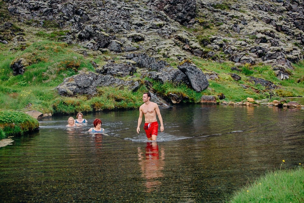
07 – Bring swimwear and a towel to enjoy the geothermal pool. There’s no better way to relax the limbs after a good hike.
08 – Don’t forget your camera, the scenery is stunning.

More Iceland Ring Road Guides
- Check out our 10-day Iceland Ring Road itinerary.
- Make sure you don’t miss our favourite places to visit in Iceland.
- Looking for accommodation on the Ring Road? Here’s where to stay in Iceland.
- Don’t miss a thermal soak with our guide to the best hot springs in Iceland.
- Just off the Ring Road is Iceland’s newest volcano – Fagradalsfjall.
- The best way to spend a day seeing Iceland’s iconic Golden Circle.
- Tips for getting good pictures of the puffins at Dyrhólaey Peninsula.
- When driving the Ring Road, don’t miss Vestrahorn – Bat Mountain.
- How to spend a few days exploring Myvatn.
- A complete list of our favourite waterfalls in Iceland.

reader-supported
When you buy through links on our site, we may earn a small affiliate commission at no extra cost to you.
Thanks for your support // Paul & Mark
Thanks for this article! We have followed the Lagahraun loop yesterday (September 2021) and it was breathtaking. One thing though, we got stuck searching for the white markers. We found out that the path was discontinued, since the only white marker we saw was covered by an arrow leading further along the yellow path. You might want to change the route into first following the fed markers and after you descent from Brennistensalda, follow the orange markers. That will take you back to the visitors center. You will miss the view from the foot of Bláhnúkur though.
Hi Arnout, Thanks very much for your kind comment and updating us on the new route. As you can imagine it’s tricky to keep everything fresh. I will amend the post as you suggest. Thanks again and glad you had a great trip.