With the ring road getting busier every year, the Iceland Highlands are the perfect choice for off-the-beaten-path travel in dramatic natural scenery. Here are the best places to visit in the Highlands.
By: Mark Barnes | Last Updated:
We’ve been to Iceland many times, and after each visit, we’re left with the same conclusion: the highlands are the most beautiful part of Iceland.
There’s simply nowhere on earth quite like it.
Majestic volcanic mountains, bubbling mud pots, rivers winding through colourful mountains, and colossal glaciers define the barren landscape.
In the emptiness of the highlands, the crowds of Reykjavík and the Ring Road (read our Ring Road Itinerary) are a distant memory.
It’s out here that the real wilderness adventure begins.
To drive yourself into the highlands, you’ll need a 4×4 vehicle, an affinity for bumpy roads and a healthy thirst for adventure.
This guide covers the best places to visit in the Iceland Highlands. For detailed information and safety tips, read our Complete Guide to the Iceland Highlands.

Map: Iceland Highlands
If you are willing to self-drive, you’re in for an exciting adventure. All the places we have recommended in the highlands are on the map below.
We also have a guide covering the best Day Trips to the Highlands. In some cases, you can see several of these sights in one day.
Click on the top right corner to open our map in your Google Maps app. Click the star next to the title to save it to your Google account.
Best Places to Visit in the Highlands
1. Kerlingarfjöll
Kerlingarfjöll is a small but stunning mountain range in the centre of Iceland. Snow-capped summits are wedged between two mighty glaciers with an otherworldly geothermal area in between.
The landscape is truly surreal. Gurgling rivers, red and brown mountains, bubbling mud pots and steaming vents shroud the valley in mystery.
You get here via the 35 and F347 roads from either north or south, and we found these to be two of the easiest mountain roads to navigate. They are rocky in a couple of places, but there are no rivers to cross, so Kerlingarfjöll is one of the most accessible places in the highlands.
More information, including hikes and driving instructions, is available on our Guide to Visiting Kerlingarfjöll.
How to Get to KerlingarfjöLL
- Route – 35 Kjölur Road and the F347.
- Difficulty – Easy F-roads with no river crossings.
- Vehicle – Any-sized 4×4 is fine for this journey.
- Time – 1.5 hours from Gullfoss; 2.5 hours via Route 1 in the north.


2. Askja
Askja is a series of interlinking calderas and craters deep in the highlands. The largest is over 30 square miles wide, formed when a massive magma chamber collapsed during a volcanic eruption.
Tucked into one edge of this massive caldera is the smaller Viti Crater, formed by a more recent explosion. The burnt-orange and yellow crater is filled with a milky-white geothermal pool.
It’s a unique and interesting landscape.
We loved Askja and have been there 3 times. But it’s one of the more difficult destinations to get to, and the scenery is no better than that of other areas in the highlands.
We think Askja is worth doing for the challenge of getting there, more than the destination itself. If you think it’s for you, read our Guide to Askja, which includes driving routes, facilities, and maps.
How to Get to Askja
- Route – F905 and F910 from Route 1.
- Difficulty – Medium to challenging: There are 2 significant river crossings.
- Vehicle – A mid-sized 4×4 is required as a minimum.
- Time – 3.5 hours from the Route 1 / F905 junction.


3. Landmannalaugar
Landmannalaugar is a mountain region in the Fjallabak National Reserve on the southwest edge of the highlands. It is the most varied of the highland landscapes with colourful rhyolite mountains, glacial rivers, lava fields and a geothermal pool.
We loved Hiking in Landmannalaugar. The trails are stunning, with great diversity from easy to strenuous hikes.
In addition to its truly remarkable scenery, Landmannalaugar is also one of the easier destinations to reach. It’s the perfect place for first-timers to get some experience on the F-Roads.
Our guide to Visiting Landmannalaugar has driving routes, hikes and maps. We also cover the different options for Getting to Landmannalaugar here.
How to Get to Landmannalaugar
- Route – F26 and F208 from the north is the easiest way to get to Landmannalaugar.
- Difficulty – Easy (no river crossings).
- Vehicle – Any 4×4 will suffice.
- Time – 1.5 hours from the Route 26 / Route 32 junction.


4. Sigöldugljúfur Canyon
A babbling brook, crossing from Krókslón Lake to Hrauneyjalón Lake, has cut a small canyon through hard black rock, producing the picture-perfect Sigöldugljúfur Canyon.
Multiple waterfalls tumble over the moss-covered, sheer-sided gorge with a turquoise river running along its base. It’s a stunning scene straight out of a fairy tale.
Sigöldugljúfur Canyon is a 45-minute drive north of Landmannalaugar on the F-208 and a great stop on your way there, which we cover in our Iceland Highlands Day Tours.
For more options on incorporating Sigöldugljúfur into your Iceland trip, read our 7-day Iceland itinerary.
How to Get to Sigöldugljúfur
- Route – F26 and F208 from the north is the easiest.
- Difficulty – Easy (no river crossings).
- Vehicle – Any 4×4 will do.
- Time – 40 minutes from the Route 26 / Route 32 junction.


5. Haifoss
Haifoss was our favourite Waterfall in Iceland. The River Fossá drops 120 metres as a slender cascade down a sheer layered rockface.
A second waterfall, Granni, drops just beside it, creating a magnificent dual waterfall in a massive, curved canyon.
It’s not technically within the highlands, but getting to Haifoss involves driving on a road that requires a 4×4 vehicle, and, because it’s such a spectacular sight, we think it’s well worth visiting.
Haifoss is also a good stop on your way to Landmannalaugar.
How to Get to Haifoss
- Route – Route 332 off Route 32.
- Difficulty – Easy (no river crossings).
- Vehicle – Any 4×4.
- Time – 20 minutes from the Route 32 / Route 332 junction.


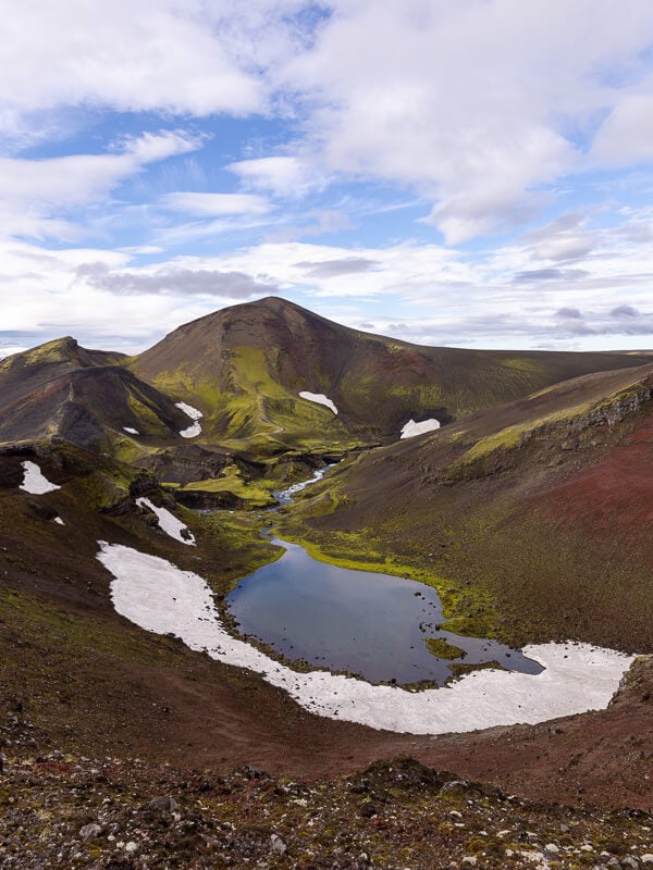
6. Ljótipollur
Ljótipollur means ‘ugly pond’ and it’s the thoroughly undeserving name for a blue lake in a 4-kilometre crater.
The barren landscape surrounding the lake has uninterrupted views of rivers twisting towards the sea with the imposing Landmannalaugar mountains behind. It’s one of the most incredible single viewpoints we found in Iceland.
There’s a new car park at Ljótipollur, which is a 5-minute walk up to the crater rim. But, if you’re feeling more active, you can see it on the wonderful hike to Ljótipollur from Landmannalaugar.
Haifoss, Sigöldugljúfur, Ljótipollur, and Landmannalaugar can all be visited in one long but glorious day. All the details are in our Guide to Landmannalaugar.
How to Get to Ljótipollur
- Route – F26 & F208.
- Difficulty – Easy (no river crossings).
- Vehicle – Any 4×4.
- Time – 1 hour, 15 minutes from Route 26 / Route 32 junction.


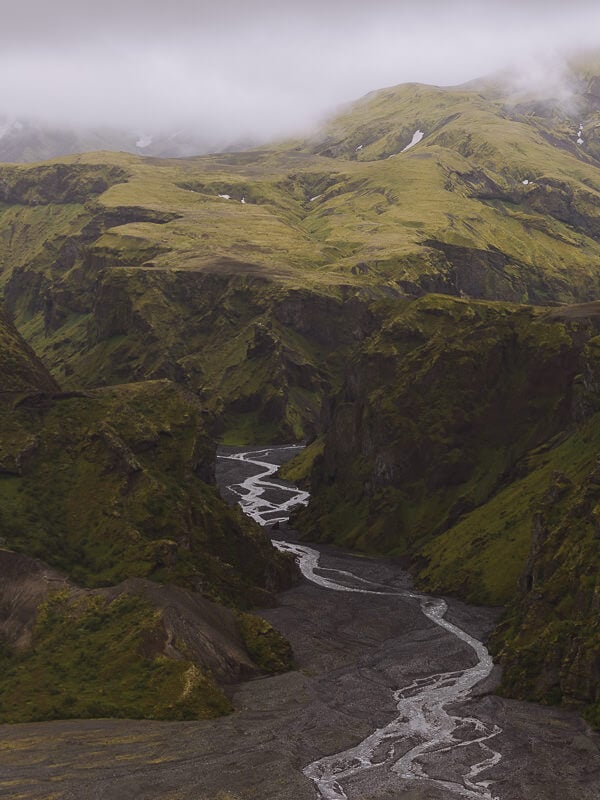
7. Thórsmörk
Thórsmörk is a remote area where three valleys converge under three imposing glaciers, forming a dramatic wilderness of spectacular scenery.
Huge moss-covered mountains, dwarfed by even bigger glaciers, are divided by a swathe of black gravel carved out by rivers charging along the valleys.
We didn’t drive ourselves to Thórsmörk because the rivers you need to cross are just too challenging for our level of 4×4 expertise.
Instead, we took the Highland Bus, a specially equipped vehicle that can navigate the serious rivers you need to cross to reach Thórsmörk.
All the details are in our Guide to Thórsmörk, which includes how to get there and the best hikes we did in the area.
How to Get to Thórsmörk
- Route – F249 to Básar Huts is the only route that does not require a specially modified 4×4.
- Difficulty – Very challenging with 2 large river crossings.
- Vehicle – Large 4×4 only (with experienced driver).
- Time – 1 hour, 10 minutes from Seljalandsfoss.


8. Maelifell
Maelifell was one of our favourite places in Iceland, let alone the highlands. It’s a dramatic cone-shaped mountain surrounded by a massive expanse of black sand. The huge Mýrdalsjökull glacier forms the background.
There are 3 different routes to Maelifell. The easiest is via the F232 from the south, a stunning drive over the Maelifellsandur black sands. It involves a river crossing that requires at least a mid-sized 4×4, but we found it relatively easy to navigate.
Our guide to Driving to Maelifel has instructions, maps and some excellent hikes.
How to Get to Maelifell
- Route – F232 from Route 209 near Hrifunes.
- Difficulty – Medium. There is 1 medium-sized river crossing, and the journey involves driving over sand.
- Vehicle – mid-sized 4×4.
- Time – 1 hour, 40 minutes one way.


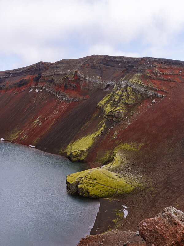
9. Rauðibotn
Rauðibotn is a red-and-green crater located between the Mýrdalsjökull and Vatnajökull glaciers.
It’s a beautiful, remote location in the highlands, with hiking trails that follow the rim of the crater to waterfalls and emerald-green lakes.
Rauðibotn has the best view we found of Maelifell sitting in the middle of the massive expanse of black sand.
We took the F210 from Grafarkirkja to Rauðibotn. It’s a pretty bumpy mountain road with a few small to medium river crossings, but it’s achievable for anyone in any-sized 4×4.
How to Get to Rauðibotn
- Route – F210 from the east (starting on the F208 near the church in Grafarkirkja).
- Difficulty – Medium. Smallish river crossings and a bumpy road.
- Vehicle – Any size 4×4.
- Time – 1 hour, 15 minutes one way.


10. Aldeyjarfoss
Aldeyjarfoss is a dramatic waterfall right on the northern edge of the F26 Sprengisandsleið Road, the longest mountain road in the highlands.
The falls are fed by the Skjálfandafljót river, which drops 20 metres in a powerful cascade to an icy-coloured pool at the base. Symmetrical basalt columns form sheer-sided walls curving around the base of the waterfall.
Aldeyjarfoss is very easy to reach from Route 1 and only takes a few minutes driving on the F-26 road.
Another waterfall, Hrafnabjargafoss, is 5 minutes further south on the F26. It’s an impressive waterfall, and if you make the quick detour, you’ll probably have it all to yourself.
How to Get to Aldeyjarfoss
- Route – 844 from Goðafoss, then F26.
- Difficulty – Easy; no river crossings, and it’s only 5 minutes on the F-road.
- Vehicle – Any 4×4.
- Time – 45 minutes.


11. Hafrahvammagljúfur
Hafrahvammagljúfur is an 8-kilometre-long canyon in a remote part of the eastern highlands. It has a spectacular drop, 200 metres down from the barren landscape around it.
The best viewing point is from a recently constructed platform, a short walk from the Hafrahvammagljúfur car park.
Access is via the F910, which is the challenging road to Askja. But this eastern end is much easier, and we thought it was a lot of fun. This road is referred to as the Roof of Iceland, with exceptional views across to the Vatnajökull glacier.
You can access the F910 from either the north (via F907) or the south (via the 910). Neither involves any river crossings, but the road is very bumpy.
How to Get to Hafrahvammagljúfur
- Route – 910 & F910 from Brekka; or F907 & F910 from Route 1 north.
- Difficulty – Easy to Medium. There are no river crossings, but the road is very bumpy.
- Vehicle – Any 4×4 will do.
- Time – 1 hour, 15 minutes, either route.


12. Laugavallalaug (Laugavellir)
Laugavallalaug (sometimes referred to as Laugavellir) is a hot spring and a beautiful oasis in the middle of nowhere.
A naturally heated waterfall drops into a small pool, dammed by stones. It was such a great find for us and, if you like remote places, the best hot spring we visited in Iceland.
The remote location, the completely natural environment, and the unforgettable views made it well worth the long journey out here.
Laugavallalaug is down a track off the west side of the F910. It is just opposite Hafrahvammagljúfur Canyon, and the two together make a great day out, especially if you include Stuðlagil Canyon and/or Hengifoss waterfall.
There is a medium-sized river crossing just before the hot springs, but there’s a car park and a footbridge, so you don’t have to drive across it if it looks too much. The pool is a 5-minute walk from the footbridge.
How to Get to Laugavallalaug
- Route – 910 & F910 from Brekka; or F907 & F910 from Route 1 north.
- Difficulty – Easy to Medium. There’s a mid-sized river crossing, which you can avoid by parking before it.
- Vehicle – Any 4×4.
- Time – 1 hour, 15 minute,s either route.


More Iceland Ring Road Guides
- Check out our 10-day Iceland Ring Road itinerary.
- Make sure you don’t miss our favourite places to visit in Iceland.
- Looking for accommodation on the Ring Road? Here’s where to stay in Iceland.
- Don’t miss a thermal soak with our guide to the best hot springs in Iceland.
- Just off the Ring Road is Iceland’s newest volcano – Fagradalsfjall.
- The best way to spend a day seeing Iceland’s iconic Golden Circle.
- Tips for getting good pictures of the puffins at Dyrhólaey Peninsula.
- When driving the Ring Road, don’t miss Vestrahorn – Bat Mountain.
- How to spend a few days exploring Myvatn.
- A complete list of our favourite waterfalls in Iceland.

reader-supported
When you buy through links on our site, we may earn a small affiliate commission at no extra cost to you.
Thanks for your support // Paul & Mark
I never got as far as the highlands of Iceland as I only had a week on the island so stuck to the tourist stuff around the capital, Golden Circule tour and blue lagoon etc but I am planning a return to the island and spending longer. I love hiking and after reading this post and looking at the photos, I want to get here as soon as possible. The waterfalls look amazing and I crave them so badly.
Hopefully, you get to go back soon and explore a bit of the highlands, it’s well worth the extra effort to see this amazing scenery. Thanks for stopping by, Danik.
We finally made it to Iceland this year. But we missed really heading inland too much. So it was great to see a teaser about what we missed. It was fascinating to learn that so much of Iceland straddles two tectonic plates. I did not know it was illegal to go into the highlands in a two wheel drive vehicle. Although I can understand why it really is only a summer activity if you head off on your own. Hveradalir looks stunning and a bit surreal with the steamy valleys. The drive to Aksja through desolate and barren scenery with lava everywhere would be amazing to see. Nice to know there are tours to see Landmannalaugar. Definitely a spot to visit when we return.
Thanks, Linda. It’s definitely great to get off the beaten track a bit in Iceland, the scenery is stunning in the highlands.
The highlands sound like such an interesting place. It surely looks perfect for a summer activity. Would love to visit Thórsmörk. Inspite of the 2 hour trek the views look magical. Including the waterfall. The volcano walk must have been adventurous.
The 2-hour trek is all part of the fun. It’s a stunning part of the country, glad you liked it, Pooja.
I knew Iceland for glaciers, northern lights and some hot springs but now reading your post made me aware of Iceland’s Highlands too. They really look vast as covering over 40,000 square kilometres means a big landscape here is of highlands.
Though these vast zones are uninhabited volcanic desert but to explore these hidden gems like colourful mountains, deep canyons, steaming volcanos, hot natural pools and bubbling mud pots would sound an interesting tour here. The geothermal area of Hveravellir looks beautiful and it would be great to soak here in between nature.
I did visit Iceland 2 years ago but had limited time so could not discover as much as I would have liked to and missed the Highlands. The highlands is certainly filled with tremendous natural beauty and as you say best time to experience this is the summer of course. I must admit I was not aware of so much of the central parts of this magnificent island and only got to know more about it from posts similar like yours. It certainly is a vast space to be true nearly 40,000 sq meters. I am planning another trip to cover the places I missed out and this will surely be included on this trip bookmarked this post. Thanks
There’s a lot to see in Iceland, Amar. If you do make it back, we highly recommend the highlands.
I didnt realize how little I knew about Iceland (like that there are volcanoes) until I read this. Sigöldugljúfur sounds like a hidden gem. I love finding these not well marked gems to explore away from the crowds.
There’s a lot to Iceland that many tourists never see. It’s well worth getting off the ring road and exploring some of the other amazing places Iceland has to offer.
Iceland has gotta be on my list for next year, the views are amazing and look so pristine. I would love to trek around the Sigöldugljúfur Canyon, it is the best kind of scenery I could see my self getting lost into :). I was never aware that Iceland got so many spectacular highlands with so many volcanic steaming mountains.
The steaming mountains were such a highlight for us. Never seen anything like it before!
Honestly, I got stuck at the pictures. They are so gorgeous and I had never read so much about the highlands of Iceland. This looks so offbeat, thrilling and fun. Kerlingarfjöll and the volcanic carters looks stunning. I would love to take a dip in the natural pools. Everything is so inspiring about this inland of Iceland..
Thanks so much, glad you liked it. The natural pools were such a cool thing to do.
I was in Iceland in October and it is such a pity that I missed out on the F roads because I had a 2WD and not a 4WD. However, whatever I did manage to see in Iceland was gorgeous and I agree, it is a unique landscape and quite amazing with the volcanic activity, the thermal natural pools and the moss! I believe a lot of these places in the highlands may not have been accessible anyway during October, so the next time I plan a trip to Iceland, it must be in the summer!
No, October might have been a bit late. You’ll have to plan another trip!
I have only visited Iceland in the winter, but have always wanted to go in summer. The highlands looks beautiful and a few of these drives I definitely want to do. Kerlingarfjöll looks amazing so I want to go there and Sigöldugljúfur Canyon, wow, that is a place I have to go and see. Thanks
Both great places. Iceland is amazing in summer as well. Have a great trip.
These photos are beautiful and your writing gives the feel of Iceland so nicely!
Thank you such much. So glad you liked it.
this place is insaaannnnneeee
and Arendelle has snow like Halstaa